Fuente de Oro geodata
Fuente de Oro (Meta) is a seat of a second-order administrative division; located in Colombia in America/Bogota (GMT-5) time zone. With population of 3,609 people, there are 620 cities with bigger population in this country. Compared to other cities in Colombia, 81.6% of cities are located further ↑North; 72.9% of cities are located further ←West and 69.7% of cities have higher elevation than Fuente de Oro. Note1


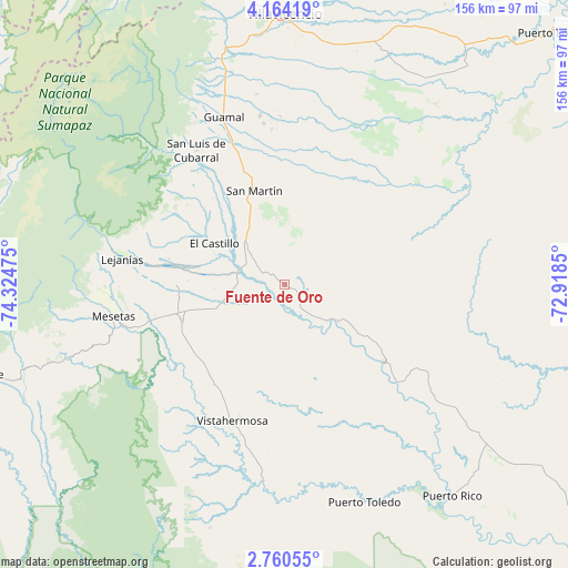
Fuente de Oro GPS coordinates[2]
3° 27' 45.468" North, 73° 37' 17.832" West
| Map corner | latitude | longitude |
|---|---|---|
| Upper-left | 4.16419°, | -74.32475° |
| Center: | 3.46263°, | -73.62162° |
| Lower-right: | 2.76055°, | -72.9185° |
| Map W x H: | 156.1×156.1 km | = 97×97mi |
| max Lat: | 13.38166° ⇑81.6% North |
| Fuente de Oro: | 3.46263° |
| min Lat: | ⇓18.4% South -4.21528° |
| min Long | Fuente de Oro | max Long |
| -81.70636° | -73.62162° | -67.06996° |
| W 72.9%⇐ | ⇒27.1% E |
Elevation
Elevation of Fuente de Oro is 301 m = 988 ft, and this is 848.3 m = 2783 ft below average elevation for this country.
| Max E: |
3342 m = 10965 ft | 69.7% |
| Avg. | 1149.3 m = 3771 ft | |
| Fuente de Oro | 301 m = 988 ft | |
Min E: |
1 m = 3 ft | 30.3% |
See also: Colombia elevation on elevation.city.
Geographical zone
Fuente de Oro is located in North Torrid zone (between Equator and Tropic of Cancer). Distance of Equator is 385 km =239.2 mi to South.| Distance of | km | miles | from Fuente de Oro |
|---|---|---|---|
| North Pole | 9622.1 | 5978.9 | to North |
| Arctic Circle | 7016.2 | 4359.7 | to North |
| Tropic Cancer | 2220.9 | 1380 | to North |
| Equator | 385 | 239.2 | to South |


Nearby cities:
15 places around Fuente de Oro: (largest is in red/bold)
• Acacías
60.2 km =37.4 mi,  345°
345°
• Castilla La Nueva
41.2 km =25.6 mi, 349°
• Cubarral
44.3 km =27.5 mi,  326°
326°
• El Castillo
22.3 km =13.9 mi,  300°
300°
• El Dorado
38.8 km =24.1 mi,  322°
322°
• Granada
13.3 km =8.3 mi,  314°
314°
• Guamal
49.1 km =30.5 mi,  341°
341°
• Lejanías
45.2 km =28.1 mi,  279°
279°
• Mesetas
47.7 km =29.6 mi,  259°
259°
• Puerto Lleras
34.8 km =21.6 mi,  128°
128°
• Puerto Lleras
54.6 km =33.9 mi,  153°
153°
• San Carlos de Guaroa
50.3 km =31.3 mi,  56°
56°
• San Juan de Arama
29.7 km =18.5 mi,  249°
249°
• San Martín
27.4 km =17 mi, 341°
• Vistahermosa
40.3 km =25 mi,  200°
200°
Sources, notices
• [Note1] Compared only with cities in Colombia existing in our database
• [Src1] Map data: © OpenStreetMap contributors (CC-BY-SA)
• [Src2] Other city data from geonames.org with taken over terms of usage.
• [Src3] Geographical zone / Annual Mean Temperature by Robert A. Rohde @ Wikipedia
