Tello geodata
Tello (Huila) is a seat of a second-order administrative division; located in Colombia in America/Bogota (GMT-5) time zone. With population of 4,868 people, there are 519 cities with bigger population in this country. Compared to other cities in Colombia, 83.9% of cities are located further ↑North; 57.3% of cities are located further →East and 62.6% of cities have higher elevation than Tello. Note1


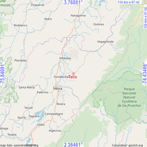
Tello GPS coordinates[2]
3° 4' 0.984" North, 75° 8' 16.008" West
| Map corner | latitude | longitude |
|---|---|---|
| Upper-left | 3.76881°, | -75.84091° |
| Center: | 3.06694°, | -75.13778° |
| Lower-right: | 2.36461°, | -74.43466° |
| Map W x H: | 156.1×156.1 km | = 97×97mi |
| max Lat: | 13.38166° ⇑83.9% North |
| Tello: | 3.06694° |
| min Lat: | ⇓16.1% South -4.21528° |
| min Long | Tello | max Long |
| -81.70636° | -75.13778° | -67.06996° |
| W 42.7%⇐ | ⇒57.3% E |
Elevation
Elevation of Tello is 581 m = 1906 ft, and this is 568.3 m = 1865 ft below average elevation for this country.
| Max E: |
3342 m = 10965 ft | 62.6% |
| Avg. | 1149.3 m = 3771 ft | |
| Tello | 581 m = 1906 ft | |
Min E: |
1 m = 3 ft | 37.4% |
See also: Colombia elevation on elevation.city.
Geographical zone
Tello is located in North Torrid zone (between Equator and Tropic of Cancer). Distance of Equator is 341 km =211.9 mi to South.| Distance of | km | miles | from Tello |
|---|---|---|---|
| North Pole | 9666.1 | 6006.2 | to North |
| Arctic Circle | 7060.2 | 4387 | to North |
| Tropic Cancer | 2264.9 | 1407.3 | to North |
| Equator | 341 | 211.9 | to South |


Nearby cities:
15 places around Tello: (largest is in red/bold)
• Aipe
20.5 km =12.7 mi,  327°
327°
• Alpujarra
42.6 km =26.5 mi,  32°
32°
• Baraya
13.4 km =8.3 mi,  44°
44°
• Campoalegre
47.2 km =29.3 mi,  205°
205°
• Colombia
50.7 km =31.5 mi,  47°
47°
• Dolores
58.9 km =36.6 mi, 26°
• Neiva
22.3 km =13.9 mi,  225°
225°
• Palermo
38.6 km =24 mi,  239°
239°
• Planadas
58.1 km =36.1 mi,  284°
284°
• Rivera
34.8 km =21.6 mi,  202°
202°
• Santa Isabel
35.9 km =22.3 mi, 29°
• Santa María
51.7 km =32.1 mi,  254°
254°
• Santa María
58.3 km =36.2 mi,  257°
257°
• Teruel
59.8 km =37.2 mi, 232°
• Villavieja
19.3 km =12 mi, 332°
Sources, notices
• [Note1] Compared only with cities in Colombia existing in our database
• [Src1] Map data: © OpenStreetMap contributors (CC-BY-SA)
• [Src2] Other city data from geonames.org with taken over terms of usage.
• [Src3] Geographical zone / Annual Mean Temperature by Robert A. Rohde @ Wikipedia
