Baraya geodata
Baraya (Huila) is a seat of a second-order administrative division; located in Colombia in America/Bogota (GMT-5) time zone. With population of 4,402 people, there are 547 cities with bigger population in this country. Compared to other cities in Colombia, 83.6% of cities are located further ↑North; 55.3% of cities are located further →East and 62% of cities have higher elevation than Baraya. Note1


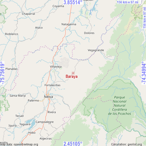
Baraya GPS coordinates[2]
3° 9' 11.988" North, 75° 3' 11.016" West
| Map corner | latitude | longitude |
|---|---|---|
| Upper-left | 3.85514°, | -75.75619° |
| Center: | 3.15333°, | -75.05306° |
| Lower-right: | 2.45105°, | -74.34994° |
| Map W x H: | 156.1×156.1 km | = 97×97mi |
| max Lat: | 13.38166° ⇑83.6% North |
| Baraya: | 3.15333° |
| min Lat: | ⇓16.4% South -4.21528° |
| min Long | Baraya | max Long |
| -81.70636° | -75.05306° | -67.06996° |
| W 44.7%⇐ | ⇒55.3% E |
Elevation
Elevation of Baraya is 612 m = 2008 ft, and this is 537.3 m = 1763 ft below average elevation for this country.
| Max E: |
3342 m = 10965 ft | 62% |
| Avg. | 1149.3 m = 3771 ft | |
| Baraya | 612 m = 2008 ft | |
Min E: |
1 m = 3 ft | 38% |
See also: Colombia elevation on elevation.city.
Geographical zone
Baraya is located in North Torrid zone (between Equator and Tropic of Cancer). Distance of Equator is 350.6 km =217.9 mi to South.| Distance of | km | miles | from Baraya |
|---|---|---|---|
| North Pole | 9656.4 | 6000.2 | to North |
| Arctic Circle | 7050.6 | 4381 | to North |
| Tropic Cancer | 2255.3 | 1401.4 | to North |
| Equator | 350.6 | 217.9 | to South |


Nearby cities:
15 places around Baraya: (largest is in red/bold)
• Aipe
21.8 km =13.5 mi,  290°
290°
• Alpujarra
29.7 km =18.5 mi,  26°
26°
• Ataco
60.9 km =37.8 mi,  323°
323°
• Campoalegre
60.1 km =37.3 mi,  209°
209°
• Colombia
37.3 km =23.2 mi,  48°
48°
• Dolores
46.2 km =28.7 mi,  21°
21°
• Natagaima
52.2 km =32.4 mi,  354°
354°
• Neiva
35.7 km =22.2 mi,  225°
225°
• Palermo
51.7 km =32.1 mi,  235°
235°
• Planadas
65.9 km =40.9 mi,  274°
274°
• Rivera
47.5 km =29.5 mi, 208°
• Santa Isabel
23.2 km =14.4 mi, 20°
• Santa María
63.8 km =39.6 mi,  248°
248°
• Tello
13.4 km =8.3 mi,  224°
224°
• Villavieja
19.8 km =12.3 mi, 292°
Sources, notices
• [Note1] Compared only with cities in Colombia existing in our database
• [Src1] Map data: © OpenStreetMap contributors (CC-BY-SA)
• [Src2] Other city data from geonames.org with taken over terms of usage.
• [Src3] Geographical zone / Annual Mean Temperature by Robert A. Rohde @ Wikipedia
