Junín geodata
Junín (Tolima) is a populated place; located in Colombia in America/Bogota (GMT-5) time zone. With population of 11,158 people, there are 274 cities with bigger population in this country. Compared to other cities in Colombia, 67% of cities are located further ↑North; 54.5% of cities are located further →East and 52.9% of cities have lower elevation than Junín. Note1


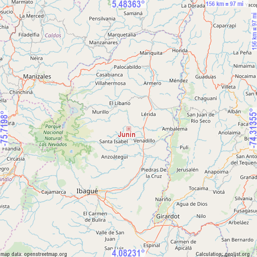
Junín GPS coordinates[2]
4° 46' 59.988" North, 75° 1' 0.012" West
| Map corner | latitude | longitude |
|---|---|---|
| Upper-left | 5.48363°, | -75.7198° |
| Center: | 4.78333°, | -75.01667° |
| Lower-right: | 4.08231°, | -74.31355° |
| Map W x H: | 155.8×155.8 km | = 96.8×96.8mi |
| max Lat: | 13.38166° ⇑67% North |
| Junín: | 4.78333° |
| min Lat: | ⇓33% South -4.21528° |
| min Long | Junín | max Long |
| -81.70636° | -75.01667° | -67.06996° |
| W 45.5%⇐ | ⇒54.5% E |
Elevation
Elevation of Junín is 1235 m = 4052 ft, and this is 85.7 m = 281 ft above average elevation for this country.
| Max E: |
3342 m = 10965 ft | 47.1% |
| Junín | 1235 m 4052 ft | |
| Avg. | 1149.3 m = 3771 ft | |
Min E: |
1 m = 3 ft | 52.9% |
See also: Colombia elevation on elevation.city.
Geographical zone
Junín is located in North Torrid zone (between Equator and Tropic of Cancer). Distance of Equator is 531.9 km =330.5 mi to South.| Distance of | km | miles | from Junín |
|---|---|---|---|
| North Pole | 9475.2 | 5887.6 | to North |
| Arctic Circle | 6869.3 | 4268.4 | to North |
| Tropic Cancer | 2074.1 | 1288.8 | to North |
| Equator | 531.9 | 330.5 | to South |


Nearby cities:
15 places around Junín: (largest is in red/bold)
• Alvarado
25 km =15.5 mi,  163°
163°
• Ambalema
28.1 km =17.5 mi,  89°
89°
• Anzoátegui
19 km =11.8 mi,  206°
206°
• Armero-Guyabal
24 km =14.9 mi,  31°
31°
• Beltrán
30.5 km =19 mi, 86°
• Casabianca
34.9 km =21.7 mi,  340°
340°
• Frías
27.4 km =17 mi,  1°
1°
• Guayabal
31.1 km =19.3 mi, 27°
• Lérida
14.8 km =9.2 mi,  53°
53°
• Líbano
16.2 km =10.1 mi, 341°
• Murillo
19.9 km =12.4 mi,  300°
300°
• Piedras
30.9 km =19.2 mi,  150°
150°
• Santa Isabel
11.8 km =7.3 mi,  229°
229°
• Venadillo
12 km =7.5 mi,  126°
126°
• Villahermosa
29.6 km =18.4 mi, 338°
Sources, notices
• [Note1] Compared only with cities in Colombia existing in our database
• [Src1] Map data: © OpenStreetMap contributors (CC-BY-SA)
• [Src2] Other city data from geonames.org with taken over terms of usage.
• [Src3] Geographical zone / Annual Mean Temperature by Robert A. Rohde @ Wikipedia
