Santa Isabel geodata
Santa Isabel (Tolima) is a seat of a second-order administrative division; located in Colombia in America/Bogota (GMT-5) time zone. In our database, there are 1053 cities with bigger population. Compared to other cities in Colombia, 68.3% of cities are located further ↑North; 56.4% of cities are located further →East and 84.9% of cities have lower elevation than Santa Isabel. Note1


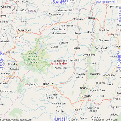
Santa Isabel GPS coordinates[2]
4° 42' 51.048" North, 75° 5' 52.764" West
| Map corner | latitude | longitude |
|---|---|---|
| Upper-left | 5.41456°, | -75.80112° |
| Center: | 4.71418°, | -75.09799° |
| Lower-right: | 4.0131°, | -74.39487° |
| Map W x H: | 155.8×155.8 km | = 96.8×96.8mi |
| max Lat: | 13.38166° ⇑68.3% North |
| Santa Isabel: | 4.71418° |
| min Lat: | ⇓31.7% South -4.21528° |
| min Long | Santa Isabel | max Long |
| -81.70636° | -75.09799° | -67.06996° |
| W 43.6%⇐ | ⇒56.4% E |
Elevation
Elevation of Santa Isabel is 2277 m = 7470 ft, and this is 1127.7 m = 3700 ft above average elevation for this country.
| Max E: |
3342 m = 10965 ft | 15.1% |
| Santa Isabel | 2277 m 7470 ft | |
| Avg. | 1149.3 m = 3771 ft | |
Min E: |
1 m = 3 ft | 84.9% |
See also: Colombia elevation on elevation.city.
Geographical zone
Santa Isabel is located in North Torrid zone (between Equator and Tropic of Cancer). Distance of Equator is 524.2 km =325.7 mi to South.| Distance of | km | miles | from Santa Isabel |
|---|---|---|---|
| North Pole | 9482.9 | 5892.4 | to North |
| Arctic Circle | 6877 | 4273.2 | to North |
| Tropic Cancer | 2081.8 | 1293.6 | to North |
| Equator | 524.2 | 325.7 | to South |


Nearby cities:
15 places around Santa Isabel: (largest is in red/bold)
• Alvarado
22.9 km =14.2 mi,  135°
135°
• Ambalema
38 km =23.6 mi,  78°
78°
• Anzoátegui
9.3 km =5.8 mi,  177°
177°
• Armero-Guyabal
35.5 km =22.1 mi,  37°
37°
• Beltrán
40.7 km =25.3 mi, 76°
• Doima
34.7 km =21.6 mi,  156°
156°
• Frías
36.5 km =22.7 mi,  15°
15°
• Ibagué
34 km =21.1 mi,  205°
205°
• Junín
11.8 km =7.3 mi,  49°
49°
• Lérida
26.6 km =16.5 mi, 51°
• Líbano
23.4 km =14.5 mi,  9°
9°
• Murillo
19.5 km =12.1 mi,  335°
335°
• Piedras
30.9 km =19.2 mi,  128°
128°
• Venadillo
18.7 km =11.6 mi,  88°
88°
• Villahermosa
35.2 km =21.9 mi,  356°
356°
Sources, notices
• [Note1] Compared only with cities in Colombia existing in our database
• [Src1] Map data: © OpenStreetMap contributors (CC-BY-SA)
• [Src2] Other city data from geonames.org with taken over terms of usage.
• [Src3] Geographical zone / Annual Mean Temperature by Robert A. Rohde @ Wikipedia
