Guapí geodata
Guapí (Cauca) is a seat of a second-order administrative division; located in Colombia in America/Bogota (GMT-5) time zone. With population of 13,853 people, there are 231 cities with bigger population in this country. Compared to other cities in Colombia, 86.6% of cities are located further ↑North; 98.8% of cities are located further →East and 99.4% of cities have higher elevation than Guapí. Note1


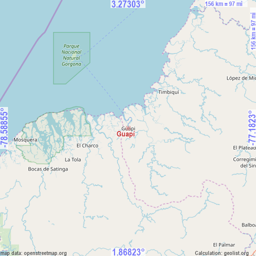
Guapí GPS coordinates[2]
2° 34' 14.952" North, 77° 53' 7.512" West
| Map corner | latitude | longitude |
|---|---|---|
| Upper-left | 3.27303°, | -78.58855° |
| Center: | 2.57082°, | -77.88542° |
| Lower-right: | 1.86823°, | -77.1823° |
| Map W x H: | 156.2×156.2 km | = 97.1×97.1mi |
| max Lat: | 13.38166° ⇑86.6% North |
| Guapí: | 2.57082° |
| min Lat: | ⇓13.4% South -4.21528° |
| min Long | Guapí | max Long |
| -81.70636° | -77.88542° | -67.06996° |
| W 1.2%⇐ | ⇒98.8% E |
Elevation
Elevation of Guapí is 3 m = 10 ft, and this is 1146.3 m = 3761 ft below average elevation for this country.
| Max E: |
3342 m = 10965 ft | 99.4% |
| Avg. | 1149.3 m = 3771 ft | |
| Guapí | 3 m = 10 ft | |
Min E: |
1 m = 3 ft | 0.6% |
See also: Colombia elevation on elevation.city.
Geographical zone
Guapí is located in North Torrid zone (between Equator and Tropic of Cancer). Distance of Equator is 285.8 km =177.6 mi to South.| Distance of | km | miles | from Guapí |
|---|---|---|---|
| North Pole | 9721.2 | 6040.5 | to North |
| Arctic Circle | 7115.3 | 4421.2 | to North |
| Tropic Cancer | 2320.1 | 1441.6 | to North |
| Equator | 285.8 | 177.6 | to South |


Nearby cities:
15 places around Guapí: (largest is in red/bold)
• Argelia
78.9 km =49 mi,  116°
116°
• Balboa
94.8 km =58.9 mi,  128°
128°
• Barbacoas
103.9 km =64.6 mi,  195°
195°
• Bocas de Satinga
54.8 km =34.1 mi,  243°
243°
• El Charco
26.9 km =16.7 mi,  247°
247°
• Iscuandé
17 km =10.6 mi,  218°
218°
• La Tola
38.8 km =24.1 mi, 240°
• Leiva
95.6 km =59.4 mi,  137°
137°
• López
77.1 km =47.9 mi,  66°
66°
• Mosquera
63.2 km =39.3 mi,  263°
263°
• Patía
108 km =67.1 mi, 121°
• Payán
95.4 km =59.3 mi, 200°
• Salahonda
104.2 km =64.7 mi, 235°
• San José
105.1 km =65.3 mi, 202°
• Timbiquí
33.1 km =20.6 mi,  47°
47°
Sources, notices
• [Note1] Compared only with cities in Colombia existing in our database
• [Src1] Map data: © OpenStreetMap contributors (CC-BY-SA)
• [Src2] Other city data from geonames.org with taken over terms of usage.
• [Src3] Geographical zone / Annual Mean Temperature by Robert A. Rohde @ Wikipedia
