Timbiquí geodata
Timbiquí (Cauca) is a seat of a second-order administrative division; located in Colombia in America/Bogota (GMT-5) time zone. With population of 6,267 people, there are 436 cities with bigger population in this country. Compared to other cities in Colombia, 85.5% of cities are located further ↑North; 98.1% of cities are located further →East and 99.2% of cities have higher elevation than Timbiquí. Note1


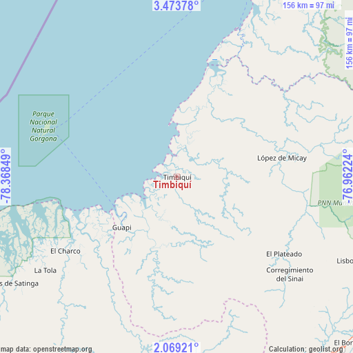
Timbiquí GPS coordinates[2]
2° 46' 18.12" North, 77° 39' 55.296" West
| Map corner | latitude | longitude |
|---|---|---|
| Upper-left | 3.47378°, | -78.36849° |
| Center: | 2.7717°, | -77.66536° |
| Lower-right: | 2.06921°, | -76.96224° |
| Map W x H: | 156.2×156.2 km | = 97.1×97.1mi |
| max Lat: | 13.38166° ⇑85.5% North |
| Timbiquí: | 2.7717° |
| min Lat: | ⇓14.5% South -4.21528° |
| min Long | Timbiquí | max Long |
| -81.70636° | -77.66536° | -67.06996° |
| W 1.9%⇐ | ⇒98.1% E |
Elevation
Elevation of Timbiquí is 4 m = 13 ft, and this is 1145.3 m = 3758 ft below average elevation for this country.
| Max E: |
3342 m = 10965 ft | 99.2% |
| Avg. | 1149.3 m = 3771 ft | |
| Timbiquí | 4 m = 13 ft | |
Min E: |
1 m = 3 ft | 0.8% |
See also: Colombia elevation on elevation.city.
Geographical zone
Timbiquí is located in North Torrid zone (between Equator and Tropic of Cancer). Distance of Equator is 308.2 km =191.5 mi to South.| Distance of | km | miles | from Timbiquí |
|---|---|---|---|
| North Pole | 9698.9 | 6026.6 | to North |
| Arctic Circle | 7093 | 4407.4 | to North |
| Tropic Cancer | 2297.7 | 1427.7 | to North |
| Equator | 308.2 | 191.5 | to South |


Nearby cities:
15 places around Timbiquí: (largest is in red/bold)
• Argelia
73.7 km =45.8 mi,  141°
141°
• Balboa
95.3 km =59.2 mi,  148°
148°
• Bocas de Satinga
87.2 km =54.2 mi,  237°
237°
• El Bordo
105.2 km =65.4 mi,  133°
133°
• El Charco
59.1 km =36.7 mi, 236°
• El Tambo
101.4 km =63 mi,  110°
110°
• Guapí
33.1 km =20.6 mi,  227°
227°
• Iscuandé
50 km =31.1 mi,  224°
224°
• La Tola
71.4 km =44.4 mi, 234°
• Leiva
101.2 km =62.9 mi,  156°
156°
• López
47.1 km =29.3 mi,  79°
79°
• López
103.2 km =64.1 mi, 111°
• Mosquera
92 km =57.2 mi,  251°
251°
• Patía
103.6 km =64.4 mi, 138°
• Villa Rica
95 km =59 mi, 107°
Sources, notices
• [Note1] Compared only with cities in Colombia existing in our database
• [Src1] Map data: © OpenStreetMap contributors (CC-BY-SA)
• [Src2] Other city data from geonames.org with taken over terms of usage.
• [Src3] Geographical zone / Annual Mean Temperature by Robert A. Rohde @ Wikipedia
