Dabeiba geodata
Dabeiba (Antioquia) is a populated place; located in Colombia in America/Bogota (GMT-5) time zone. With population of 11,548 people, there are 262 cities with bigger population in this country. Compared to other cities in Colombia, 74.2% of cities are located further ↓South; 84.3% of cities are located further →East and 64% of cities have higher elevation than Dabeiba. Note1


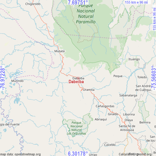
Dabeiba GPS coordinates[2]
7° 0' 0.612" North, 76° 16' 8.94" West
| Map corner | latitude | longitude |
|---|---|---|
| Upper-left | 7.69751°, | -76.97228° |
| Center: | 7.00017°, | -76.26915° |
| Lower-right: | 6.30178°, | -75.56603° |
| Map W x H: | 155.2×155.2 km | = 96.4×96.4mi |
| max Lat: | 13.38166° ⇑25.8% North |
| Dabeiba: | 7.00017° |
| min Lat: | ⇓74.2% South -4.21528° |
| min Long | Dabeiba | max Long |
| -81.70636° | -76.26915° | -67.06996° |
| W 15.7%⇐ | ⇒84.3% E |
Elevation
Elevation of Dabeiba is 488 m = 1601 ft, and this is 661.3 m = 2170 ft below average elevation for this country.
| Max E: |
3342 m = 10965 ft | 64% |
| Avg. | 1149.3 m = 3771 ft | |
| Dabeiba | 488 m = 1601 ft | |
Min E: |
1 m = 3 ft | 36% |
See also: Colombia elevation on elevation.city.
Geographical zone
Dabeiba is located in North Torrid zone (between Equator and Tropic of Cancer). Distance of Equator is 778.3 km =483.6 mi to South.| Distance of | km | miles | from Dabeiba |
|---|---|---|---|
| North Pole | 9228.7 | 5734.4 | to North |
| Arctic Circle | 6622.8 | 4115.2 | to North |
| Tropic Cancer | 1827.6 | 1135.6 | to North |
| Equator | 778.3 | 483.6 | to South |


Nearby cities:
15 places around Dabeiba: (largest is in red/bold)
• Abriaquí
46.8 km =29.1 mi,  151°
151°
• Buriticá
50.7 km =31.5 mi,  128°
128°
• Cañasgordas
38.7 km =24 mi,  135°
135°
• Frontino
29.5 km =18.3 mi, 149°
• Giraldo
49.9 km =31 mi, 135°
• Ituango
58.9 km =36.6 mi,  71°
71°
• Liborina
61.9 km =38.5 mi, 125°
• Murindó
61 km =37.9 mi,  267°
267°
• Mutatá
32.8 km =20.4 mi,  325°
325°
• Olaya
65.2 km =40.5 mi, 129°
• Peque
39.8 km =24.7 mi,  86°
86°
• Sabanalarga
52.7 km =32.7 mi,  108°
108°
• San Andrés
65.6 km =40.8 mi,  99°
99°
• Toledo
63.3 km =39.3 mi, 88°
• Uramita
15.3 km =9.5 mi, 136°
Sources, notices
• [Note1] Compared only with cities in Colombia existing in our database
• [Src1] Map data: © OpenStreetMap contributors (CC-BY-SA)
• [Src2] Other city data from geonames.org with taken over terms of usage.
• [Src3] Geographical zone / Annual Mean Temperature by Robert A. Rohde @ Wikipedia
