Mutatá geodata
Mutatá (Antioquia) is a seat of a second-order administrative division; located in Colombia in America/Bogota (GMT-5) time zone. With population of 4,811 people, there are 523 cities with bigger population in this country. Compared to other cities in Colombia, 76.3% of cities are located further ↓South; 86.1% of cities are located further →East and 79% of cities have higher elevation than Mutatá. Note1


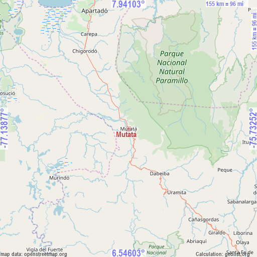
Mutatá GPS coordinates[2]
7° 14' 38.652" North, 76° 26' 8.304" West
| Map corner | latitude | longitude |
|---|---|---|
| Upper-left | 7.94103°, | -77.13877° |
| Center: | 7.24407°, | -76.43564° |
| Lower-right: | 6.54603°, | -75.73252° |
| Map W x H: | 155.1×155.1 km | = 96.4×96.4mi |
| max Lat: | 13.38166° ⇑23.7% North |
| Mutatá: | 7.24407° |
| min Lat: | ⇓76.3% South -4.21528° |
| min Long | Mutatá | max Long |
| -81.70636° | -76.43564° | -67.06996° |
| W 13.9%⇐ | ⇒86.1% E |
Elevation
Elevation of Mutatá is 132 m = 433 ft, and this is 1017.3 m = 3338 ft below average elevation for this country.
| Max E: |
3342 m = 10965 ft | 79% |
| Avg. | 1149.3 m = 3771 ft | |
| Mutatá | 132 m = 433 ft | |
Min E: |
1 m = 3 ft | 21% |
See also: Colombia elevation on elevation.city.
Geographical zone
Mutatá is located in North Torrid zone (between Equator and Tropic of Cancer). Distance of Equator is 805.5 km =500.5 mi to South.| Distance of | km | miles | from Mutatá |
|---|---|---|---|
| North Pole | 9201.6 | 5717.6 | to North |
| Arctic Circle | 6595.7 | 4098.4 | to North |
| Tropic Cancer | 1800.5 | 1118.8 | to North |
| Equator | 805.5 | 500.5 | to South |


Nearby cities:
15 places around Mutatá: (largest is in red/bold)
• Abriaquí
79.5 km =49.4 mi,  148°
148°
• Apartadó
74.1 km =46 mi,  343°
343°
• Carepa
62 km =38.5 mi, 337°
• Cañasgordas
71.2 km =44.2 mi,  140°
140°
• Chigorodó
54.2 km =33.7 mi,  330°
330°
• Curbaradó
59.8 km =37.2 mi,  260°
260°
• Dabeiba
32.8 km =20.4 mi, 145°
• Frontino
62.3 km =38.7 mi, 147°
• Giraldo
82.3 km =51.1 mi, 139°
• Ituango
74.5 km =46.3 mi,  96°
96°
• Murindó
51.7 km =32.1 mi,  235°
235°
• Peque
63.1 km =39.2 mi,  113°
113°
• Riosucio
78.6 km =48.8 mi,  286°
286°
• Sabanalarga
81.2 km =50.5 mi,  122°
122°
• Uramita
48 km =29.8 mi, 143°
Sources, notices
• [Note1] Compared only with cities in Colombia existing in our database
• [Src1] Map data: © OpenStreetMap contributors (CC-BY-SA)
• [Src2] Other city data from geonames.org with taken over terms of usage.
• [Src3] Geographical zone / Annual Mean Temperature by Robert A. Rohde @ Wikipedia
