Murindó geodata
Murindó (Antioquia) is a seat of a second-order administrative division; located in Colombia in America/Bogota (GMT-5) time zone. With population of 2,372 people, there are 758 cities with bigger population in this country. Compared to other cities in Colombia, 73.9% of cities are located further ↓South; 90.8% of cities are located further →East and 87.1% of cities have higher elevation than Murindó. Note1


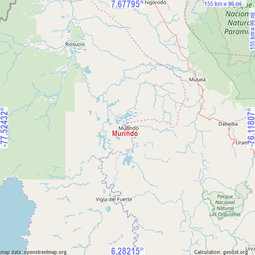
Murindó GPS coordinates[2]
6° 58' 50.052" North, 76° 49' 16.284" West
| Map corner | latitude | longitude |
|---|---|---|
| Upper-left | 7.67795°, | -77.52432° |
| Center: | 6.98057°, | -76.82119° |
| Lower-right: | 6.28215°, | -76.11807° |
| Map W x H: | 155.2×155.2 km | = 96.4×96.4mi |
| max Lat: | 13.38166° ⇑26.1% North |
| Murindó: | 6.98057° |
| min Lat: | ⇓73.9% South -4.21528° |
| min Long | Murindó | max Long |
| -81.70636° | -76.82119° | -67.06996° |
| W 9.2%⇐ | ⇒90.8% E |
Elevation
Elevation of Murindó is 45 m = 148 ft, and this is 1104.3 m = 3623 ft below average elevation for this country.
| Max E: |
3342 m = 10965 ft | 87.1% |
| Avg. | 1149.3 m = 3771 ft | |
| Murindó | 45 m = 148 ft | |
Min E: |
1 m = 3 ft | 12.9% |
See also: Colombia elevation on elevation.city.
Geographical zone
Murindó is located in North Torrid zone (between Equator and Tropic of Cancer). Distance of Equator is 776.2 km =482.3 mi to South.| Distance of | km | miles | from Murindó |
|---|---|---|---|
| North Pole | 9230.9 | 5735.8 | to North |
| Arctic Circle | 6625 | 4116.6 | to North |
| Tropic Cancer | 1829.8 | 1137 | to North |
| Equator | 776.2 | 482.3 | to South |


Nearby cities:
15 places around Murindó: (largest is in red/bold)
• Abriaquí
92.1 km =57.2 mi,  114°
114°
• Apartadó
102.6 km =63.8 mi,  12°
12°
• Bellavista
47.7 km =29.6 mi,  188°
188°
• Carepa
88.5 km =55 mi, 12°
• Cañasgordas
91.5 km =56.9 mi, 106°
• Chigorodó
77.8 km =48.3 mi, 11°
• Curbaradó
25.7 km =16 mi,  319°
319°
• Dabeiba
61 km =37.9 mi,  87°
87°
• Frontino
79.4 km =49.3 mi, 107°
• Giraldo
101.5 km =63.1 mi, 109°
• Mutatá
51.7 km =32.1 mi,  55°
55°
• Peque
100.7 km =62.6 mi, 87°
• Riosucio
61.1 km =38 mi,  327°
327°
• Uramita
72 km =44.7 mi,  97°
97°
• Vigía del Fuerte
44.3 km =27.5 mi, 190°
Sources, notices
• [Note1] Compared only with cities in Colombia existing in our database
• [Src1] Map data: © OpenStreetMap contributors (CC-BY-SA)
• [Src2] Other city data from geonames.org with taken over terms of usage.
• [Src3] Geographical zone / Annual Mean Temperature by Robert A. Rohde @ Wikipedia
