La Chamba geodata
La Chamba (Tolima) is a populated place; located in Colombia in America/Bogota (GMT-5) time zone. With population of 7,075 people, there are 402 cities with bigger population in this country. Compared to other cities in Colombia, 77.8% of cities are located further ↑North; 50.6% of cities are located further →East and 70.1% of cities have higher elevation than La Chamba. Note1


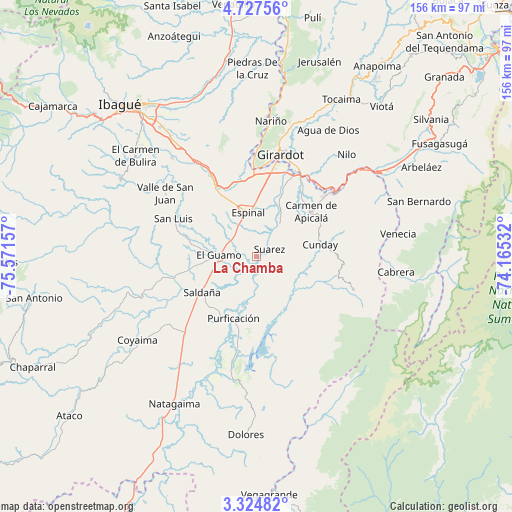
La Chamba GPS coordinates[2]
4° 1' 35.364" North, 74° 52' 6.384" West
| Map corner | latitude | longitude |
|---|---|---|
| Upper-left | 4.72756°, | -75.57157° |
| Center: | 4.02649°, | -74.86844° |
| Lower-right: | 3.32482°, | -74.16532° |
| Map W x H: | 156×156 km | = 96.9×96.9mi |
| max Lat: | 13.38166° ⇑77.8% North |
| La Chamba: | 4.02649° |
| min Lat: | ⇓22.2% South -4.21528° |
| min Long | La Chamba | max Long |
| -81.70636° | -74.86844° | -67.06996° |
| W 49.4%⇐ | ⇒50.6% E |
Elevation
Elevation of La Chamba is 294 m = 965 ft, and this is 855.3 m = 2806 ft below average elevation for this country.
| Max E: |
3342 m = 10965 ft | 70.1% |
| Avg. | 1149.3 m = 3771 ft | |
| La Chamba | 294 m = 965 ft | |
Min E: |
1 m = 3 ft | 29.9% |
See also: Colombia elevation on elevation.city.
Geographical zone
La Chamba is located in North Torrid zone (between Equator and Tropic of Cancer). Distance of Equator is 447.7 km =278.2 mi to South.| Distance of | km | miles | from La Chamba |
|---|---|---|---|
| North Pole | 9559.4 | 5939.9 | to North |
| Arctic Circle | 6953.5 | 4320.7 | to North |
| Tropic Cancer | 2158.2 | 1341 | to North |
| Equator | 447.7 | 278.2 | to South |


Nearby cities:
15 places around La Chamba: (largest is in red/bold)
• Carmen de Apicalá
21.2 km =13.2 mi,  50°
50°
• Chicoral
24.5 km =15.2 mi,  329°
329°
• Coello
29.4 km =18.3 mi,  353°
353°
• Cunday
19.9 km =12.4 mi,  79°
79°
• Espinal
13.8 km =8.6 mi, 352°
• Flandes
29.9 km =18.6 mi,  11°
11°
• Girardot City
31.2 km =19.4 mi, 12°
• Guamo
11.3 km =7 mi,  272°
272°
• Purificación
19.9 km =12.4 mi,  200°
200°
• Ricaurte
30.5 km =19 mi,  22°
22°
• Saldaña
19.5 km =12.1 mi,  236°
236°
• San Luis
27.8 km =17.3 mi,  295°
295°
• Suárez
4.8 km =3 mi,  58°
58°
• Tres Esquinas
25.2 km =15.7 mi,  135°
135°
• Villarrica
31.4 km =19.5 mi,  108°
108°
Sources, notices
• [Note1] Compared only with cities in Colombia existing in our database
• [Src1] Map data: © OpenStreetMap contributors (CC-BY-SA)
• [Src2] Other city data from geonames.org with taken over terms of usage.
• [Src3] Geographical zone / Annual Mean Temperature by Robert A. Rohde @ Wikipedia
