Caucasia geodata
Caucasia (Antioquia) is a seat of a second-order administrative division; located in Colombia in America/Bogota (GMT-5) time zone. With population of 58,034 people, there are 69 cities with bigger population in this country. Compared to other cities in Colombia, 80.8% of cities are located further ↓South; 59.2% of cities are located further →East and 86.3% of cities have higher elevation than Caucasia. Note1


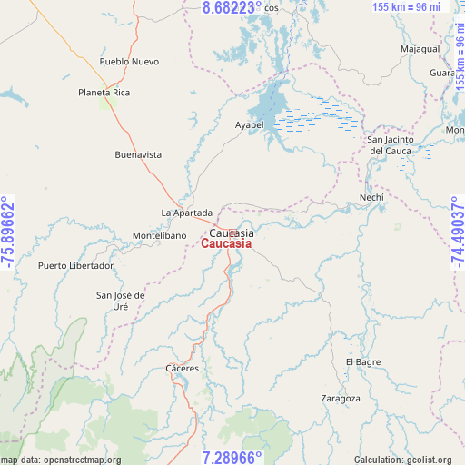
Caucasia GPS coordinates[2]
7° 59' 11.544" North, 75° 11' 36.564" West
| Map corner | latitude | longitude |
|---|---|---|
| Upper-left | 8.68223°, | -75.89662° |
| Center: | 7.98654°, | -75.19349° |
| Lower-right: | 7.28966°, | -74.49037° |
| Map W x H: | 154.8×154.8 km | = 96.2×96.2mi |
| max Lat: | 13.38166° ⇑19.2% North |
| Caucasia: | 7.98654° |
| min Lat: | ⇓80.8% South -4.21528° |
| min Long | Caucasia | max Long |
| -81.70636° | -75.19349° | -67.06996° |
| W 40.8%⇐ | ⇒59.2% E |
Elevation
Elevation of Caucasia is 50 m = 164 ft, and this is 1099.3 m = 3607 ft below average elevation for this country.
| Max E: |
3342 m = 10965 ft | 86.3% |
| Avg. | 1149.3 m = 3771 ft | |
| Caucasia | 50 m = 164 ft | |
Min E: |
1 m = 3 ft | 13.7% |
See also: Caucasia elevation on elevation.city.
Geographical zone
Caucasia is located in North Torrid zone (between Equator and Tropic of Cancer). Distance of Equator is 888 km =551.8 mi to South.| Distance of | km | miles | from Caucasia |
|---|---|---|---|
| North Pole | 9119 | 5666.3 | to North |
| Arctic Circle | 6513.2 | 4047.1 | to North |
| Tropic Cancer | 1717.9 | 1067.5 | to North |
| Equator | 888 | 551.8 | to South |


Nearby cities:
15 places around Caucasia: (largest is in red/bold)
• Ayapel
36.9 km =22.9 mi,  9°
9°
• Buenavista
41.2 km =25.6 mi,  309°
309°
• Cáceres
48.2 km =30 mi,  200°
200°
• El Bagre
60 km =37.3 mi,  135°
135°
• La Apartada
17.3 km =10.7 mi,  293°
293°
• Montelíbano
25 km =15.5 mi,  268°
268°
• Nechí
47.5 km =29.5 mi,  75°
75°
• Planeta Rica
64 km =39.8 mi,  317°
317°
• Pueblo Nuevo
38.4 km =23.9 mi,  42°
42°
• Puerto Libertador
53.6 km =33.3 mi,  258°
258°
• San Carlos
51.1 km =31.8 mi,  115°
115°
• San Jacinto del Cauca
59.7 km =37.1 mi,  60°
60°
• San José de Uré
43.6 km =27.1 mi,  239°
239°
• Tarazá
50.3 km =31.3 mi,  206°
206°
• Zaragoza
65.8 km =40.9 mi,  147°
147°
Sources, notices
• [Note1] Compared only with cities in Colombia existing in our database
• [Src1] Map data: © OpenStreetMap contributors (CC-BY-SA)
• [Src2] Other city data from geonames.org with taken over terms of usage.
• [Src3] Geographical zone / Annual Mean Temperature by Robert A. Rohde @ Wikipedia
