El Bagre geodata
El Bagre (Antioquia) is a populated place; located in Colombia in America/Bogota (GMT-5) time zone. With population of 40,798 people, there are 95 cities with bigger population in this country. Compared to other cities in Colombia, 78.5% of cities are located further ↓South; 50.4% of cities are located further ←West and 86% of cities have higher elevation than El Bagre. Note1


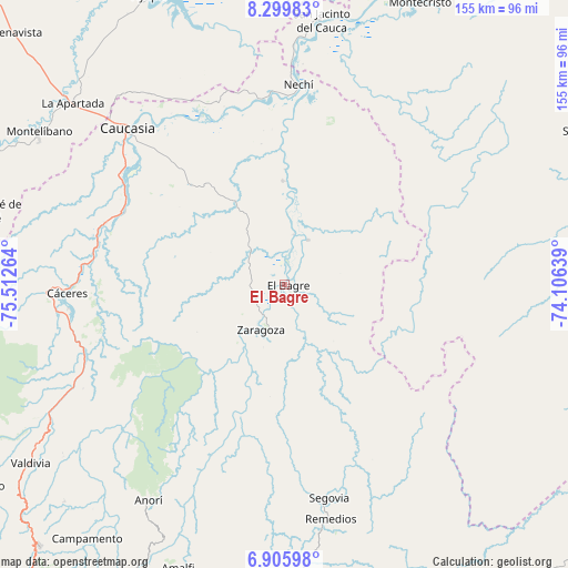
El Bagre GPS coordinates[2]
7° 36' 12.492" North, 74° 48' 34.236" West
| Map corner | latitude | longitude |
|---|---|---|
| Upper-left | 8.29983°, | -75.51264° |
| Center: | 7.60347°, | -74.80951° |
| Lower-right: | 6.90598°, | -74.10639° |
| Map W x H: | 155×155 km | = 96.3×96.3mi |
| max Lat: | 13.38166° ⇑21.5% North |
| El Bagre: | 7.60347° |
| min Lat: | ⇓78.5% South -4.21528° |
| min Long | El Bagre | max Long |
| -81.70636° | -74.80951° | -67.06996° |
| W 50.4%⇐ | ⇒49.6% E |
Elevation
Elevation of El Bagre is 51 m = 167 ft, and this is 1098.3 m = 3603 ft below average elevation for this country.
| Max E: |
3342 m = 10965 ft | 86% |
| Avg. | 1149.3 m = 3771 ft | |
| El Bagre | 51 m = 167 ft | |
Min E: |
1 m = 3 ft | 14% |
See also: El Bagre elevation on elevation.city.
Geographical zone
El Bagre is located in North Torrid zone (between Equator and Tropic of Cancer). Distance of Equator is 845.4 km =525.3 mi to South.| Distance of | km | miles | from El Bagre |
|---|---|---|---|
| North Pole | 9161.6 | 5692.8 | to North |
| Arctic Circle | 6555.7 | 4073.5 | to North |
| Tropic Cancer | 1760.5 | 1093.9 | to North |
| Equator | 845.4 | 525.3 | to South |


Nearby cities:
15 places around El Bagre: (largest is in red/bold)
• Anorí
69.8 km =43.4 mi,  212°
212°
• Caucasia
60 km =37.3 mi,  315°
315°
• Cruces de Anorí
54.6 km =33.9 mi, 211°
• Cáceres
59.4 km =36.9 mi,  267°
267°
• La Apartada
76.4 km =47.5 mi,  310°
310°
• Montelíbano
79.2 km =49.2 mi,  301°
301°
• Nechí
54.7 km =34 mi,  3°
3°
• Pueblo Nuevo
72.8 km =45.2 mi,  346°
346°
• Remedios
65.2 km =40.5 mi,  168°
168°
• San Carlos
21.3 km =13.2 mi,  10°
10°
• San Jacinto del Cauca
72.5 km =45 mi, 7°
• Segovia
59.5 km =37 mi, 168°
• Tarazá
65.2 km =40.5 mi, 268°
• Valdivia
72.9 km =45.3 mi,  241°
241°
• Zaragoza
14.3 km =8.9 mi, 207°
Sources, notices
• [Note1] Compared only with cities in Colombia existing in our database
• [Src1] Map data: © OpenStreetMap contributors (CC-BY-SA)
• [Src2] Other city data from geonames.org with taken over terms of usage.
• [Src3] Geographical zone / Annual Mean Temperature by Robert A. Rohde @ Wikipedia
