Zaragoza geodata
Zaragoza (Antioquia) is a seat of a second-order administrative division; located in Colombia in America/Bogota (GMT-5) time zone. With population of 18,795 people, there are 190 cities with bigger population in this country. Compared to other cities in Colombia, 78% of cities are located further ↓South; 50.7% of cities are located further →East and 84.5% of cities have higher elevation than Zaragoza. Note1


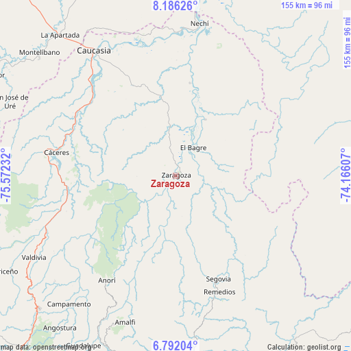
Zaragoza GPS coordinates[2]
7° 29' 22.956" North, 74° 52' 9.084" West
| Map corner | latitude | longitude |
|---|---|---|
| Upper-left | 8.18626°, | -75.57232° |
| Center: | 7.48971°, | -74.86919° |
| Lower-right: | 6.79204°, | -74.16607° |
| Map W x H: | 155×155 km | = 96.3×96.3mi |
| max Lat: | 13.38166° ⇑22% North |
| Zaragoza: | 7.48971° |
| min Lat: | ⇓78% South -4.21528° |
| min Long | Zaragoza | max Long |
| -81.70636° | -74.86919° | -67.06996° |
| W 49.3%⇐ | ⇒50.7% E |
Elevation
Elevation of Zaragoza is 66 m = 217 ft, and this is 1083.3 m = 3554 ft below average elevation for this country.
| Max E: |
3342 m = 10965 ft | 84.5% |
| Avg. | 1149.3 m = 3771 ft | |
| Zaragoza | 66 m = 217 ft | |
Min E: |
1 m = 3 ft | 15.5% |
See also: Colombia elevation on elevation.city.
Geographical zone
Zaragoza is located in North Torrid zone (between Equator and Tropic of Cancer). Distance of Equator is 832.8 km =517.5 mi to South.| Distance of | km | miles | from Zaragoza |
|---|---|---|---|
| North Pole | 9174.3 | 5700.6 | to North |
| Arctic Circle | 6568.4 | 4081.4 | to North |
| Tropic Cancer | 1773.1 | 1101.8 | to North |
| Equator | 832.8 | 517.5 | to South |


Nearby cities:
15 places around Zaragoza: (largest is in red/bold)
• Amalfi
68.4 km =42.5 mi,  199°
199°
• Anorí
55.6 km =34.5 mi,  213°
213°
• Campamento
73.8 km =45.9 mi,  219°
219°
• Caucasia
65.8 km =40.9 mi,  327°
327°
• Cruces de Anorí
40.4 km =25.1 mi, 212°
• Cáceres
53.8 km =33.4 mi,  280°
280°
• El Bagre
14.3 km =8.9 mi,  27°
27°
• Nechí
68 km =42.3 mi,  8°
8°
• Remedios
54.8 km =34.1 mi,  159°
159°
• San Carlos
35.2 km =21.9 mi,  17°
17°
• San José de Uré
80.3 km =49.9 mi,  294°
294°
• Segovia
49.3 km =30.6 mi, 157°
• Tarazá
59.5 km =37 mi, 280°
• Valdivia
61.6 km =38.3 mi,  249°
249°
• Valdivia
72.5 km =45 mi,  240°
240°
Sources, notices
• [Note1] Compared only with cities in Colombia existing in our database
• [Src1] Map data: © OpenStreetMap contributors (CC-BY-SA)
• [Src2] Other city data from geonames.org with taken over terms of usage.
• [Src3] Geographical zone / Annual Mean Temperature by Robert A. Rohde @ Wikipedia
