Anzoátegui geodata
Anzoátegui (Tolima) is a seat of a second-order administrative division; located in Colombia in America/Bogota (GMT-5) time zone. With population of 2,229 people, there are 774 cities with bigger population in this country. Compared to other cities in Colombia, 69.2% of cities are located further ↑North; 56.1% of cities are located further →East and 71.6% of cities have lower elevation than Anzoátegui. Note1


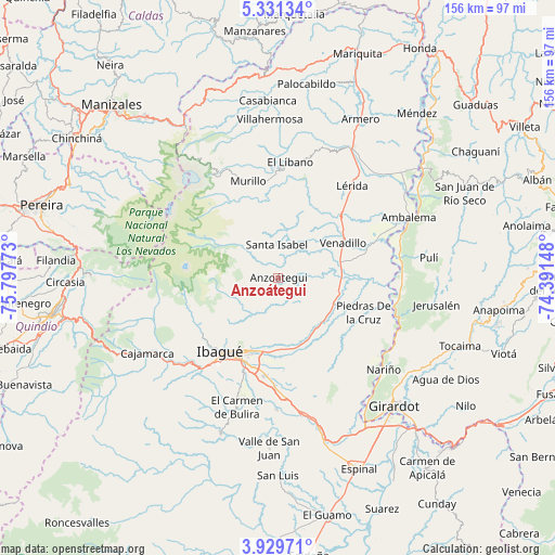
Anzoátegui GPS coordinates[2]
4° 37' 51.132" North, 75° 5' 40.56" West
| Map corner | latitude | longitude |
|---|---|---|
| Upper-left | 5.33134°, | -75.79773° |
| Center: | 4.63087°, | -75.0946° |
| Lower-right: | 3.92971°, | -74.39148° |
| Map W x H: | 155.8×155.8 km | = 96.8×96.8mi |
| max Lat: | 13.38166° ⇑69.2% North |
| Anzoátegui: | 4.63087° |
| min Lat: | ⇓30.8% South -4.21528° |
| min Long | Anzoátegui | max Long |
| -81.70636° | -75.0946° | -67.06996° |
| W 43.9%⇐ | ⇒56.1% E |
Elevation
Elevation of Anzoátegui is 1767 m = 5797 ft, and this is 617.7 m = 2027 ft above average elevation for this country.
| Max E: |
3342 m = 10965 ft | 28.4% |
| Anzoátegui | 1767 m 5797 ft | |
| Avg. | 1149.3 m = 3771 ft | |
Min E: |
1 m = 3 ft | 71.6% |
See also: Colombia elevation on elevation.city.
Geographical zone
Anzoátegui is located in North Torrid zone (between Equator and Tropic of Cancer). Distance of Equator is 514.9 km =319.9 mi to South.| Distance of | km | miles | from Anzoátegui |
|---|---|---|---|
| North Pole | 9492.2 | 5898.2 | to North |
| Arctic Circle | 6886.3 | 4278.9 | to North |
| Tropic Cancer | 2091 | 1299.3 | to North |
| Equator | 514.9 | 319.9 | to South |


Nearby cities:
15 places around Anzoátegui: (largest is in red/bold)
• Alvarado
17.2 km =10.7 mi,  113°
113°
• Ambalema
40.5 km =25.2 mi,  65°
65°
• Coello
33.6 km =20.9 mi,  221°
221°
• Doima
26.2 km =16.3 mi,  149°
149°
• Guataquí
36.2 km =22.5 mi, 110°
• Ibagué
26.2 km =16.3 mi, 215°
• Junín
19 km =11.8 mi,  26°
26°
• Lérida
32.9 km =20.4 mi,  38°
38°
• Líbano
32.5 km =20.2 mi,  6°
6°
• Murillo
28.3 km =17.6 mi,  342°
342°
• Nariño
39.4 km =24.5 mi,  131°
131°
• Payandé
37.1 km =23.1 mi,  180°
180°
• Piedras
25.9 km =16.1 mi, 112°
• Santa Isabel
9.3 km =5.8 mi,  357°
357°
• Venadillo
20.8 km =12.9 mi,  61°
61°
Sources, notices
• [Note1] Compared only with cities in Colombia existing in our database
• [Src1] Map data: © OpenStreetMap contributors (CC-BY-SA)
• [Src2] Other city data from geonames.org with taken over terms of usage.
• [Src3] Geographical zone / Annual Mean Temperature by Robert A. Rohde @ Wikipedia
