Guamal geodata
Guamal (Meta) is a seat of a second-order administrative division; located in Colombia in America/Bogota (GMT-5) time zone. With population of 5,026 people, there are 507 cities with bigger population in this country. Compared to other cities in Colombia, 78.9% of cities are located further ↑North; 70.7% of cities are located further ←West and 63.6% of cities have higher elevation than Guamal. Note1


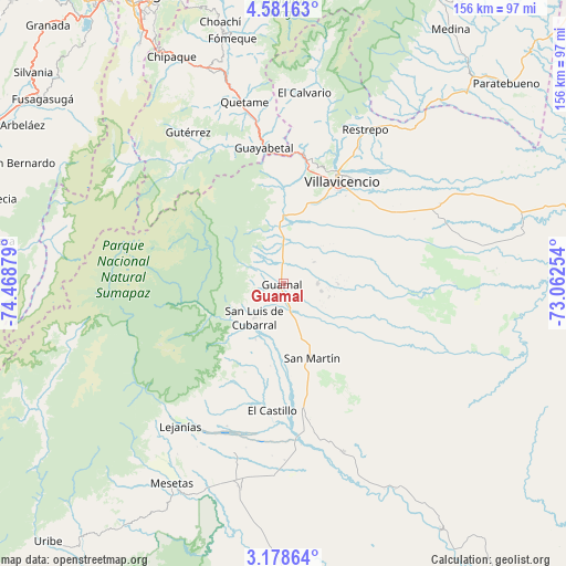
Guamal GPS coordinates[2]
3° 52' 49.548" North, 73° 45' 56.376" West
| Map corner | latitude | longitude |
|---|---|---|
| Upper-left | 4.58163°, | -74.46879° |
| Center: | 3.88043°, | -73.76566° |
| Lower-right: | 3.17864°, | -73.06254° |
| Map W x H: | 156×156 km | = 96.9×96.9mi |
| max Lat: | 13.38166° ⇑78.9% North |
| Guamal: | 3.88043° |
| min Lat: | ⇓21.1% South -4.21528° |
| min Long | Guamal | max Long |
| -81.70636° | -73.76566° | -67.06996° |
| W 70.7%⇐ | ⇒29.3% E |
Elevation
Elevation of Guamal is 522 m = 1713 ft, and this is 627.3 m = 2058 ft below average elevation for this country.
| Max E: |
3342 m = 10965 ft | 63.6% |
| Avg. | 1149.3 m = 3771 ft | |
| Guamal | 522 m = 1713 ft | |
Min E: |
1 m = 3 ft | 36.4% |
See also: Colombia elevation on elevation.city.
Geographical zone
Guamal is located in North Torrid zone (between Equator and Tropic of Cancer). Distance of Equator is 431.5 km =268.1 mi to South.| Distance of | km | miles | from Guamal |
|---|---|---|---|
| North Pole | 9575.6 | 5950 | to North |
| Arctic Circle | 6969.7 | 4330.8 | to North |
| Tropic Cancer | 2174.5 | 1351.2 | to North |
| Equator | 431.5 | 268.1 | to South |


Nearby cities:
15 places around Guamal: (largest is in red/bold)
• Acacías
11.9 km =7.4 mi,  4°
4°
• Castilla La Nueva
10.4 km =6.5 mi,  124°
124°
• Cubarral
12.6 km =7.8 mi,  221°
221°
• El Calvario
52.9 km =32.9 mi,  6°
6°
• El Castillo
35.4 km =22 mi,  185°
185°
• El Dorado
17.5 km =10.9 mi,  206°
206°
• Fuente de Oro
49.1 km =30.5 mi,  161°
161°
• Granada
37.7 km =23.4 mi,  170°
170°
• Guayabetal
37.6 km =23.4 mi,  351°
351°
• Gutiérrez
49.2 km =30.6 mi,  327°
327°
• Lejanías
48.5 km =30.1 mi, 216°
• Quetame
51.4 km =31.9 mi, 348°
• Restrepo
47.7 km =29.6 mi,  28°
28°
• San Martín
21.7 km =13.5 mi, 160°
• Villavicencio
32.9 km =20.4 mi, 27°
Sources, notices
• [Note1] Compared only with cities in Colombia existing in our database
• [Src1] Map data: © OpenStreetMap contributors (CC-BY-SA)
• [Src2] Other city data from geonames.org with taken over terms of usage.
• [Src3] Geographical zone / Annual Mean Temperature by Robert A. Rohde @ Wikipedia
