Uribe geodata
Uribe (Meta) is a seat of a second-order administrative division; located in Colombia in America/Bogota (GMT-5) time zone. In our database, there are 1053 cities with bigger population. Compared to other cities in Colombia, 82.8% of cities are located further ↑North; 59.3% of cities are located further ←West and 60.5% of cities have higher elevation than Uribe. Note1


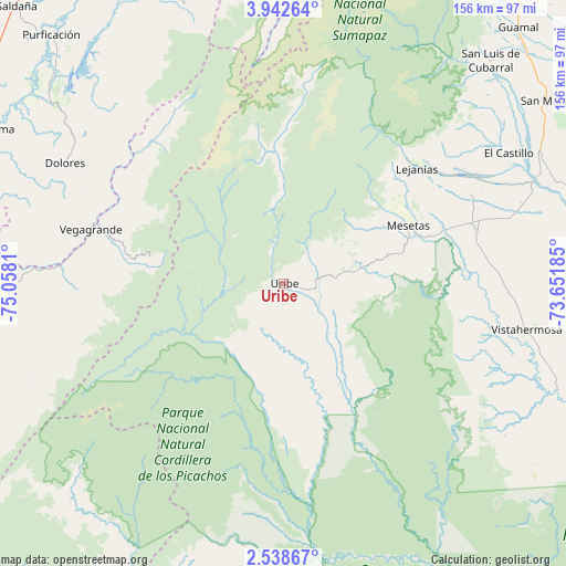
Uribe GPS coordinates[2]
3° 14' 27.24" North, 74° 21' 17.892" West
| Map corner | latitude | longitude |
|---|---|---|
| Upper-left | 3.94264°, | -75.0581° |
| Center: | 3.2409°, | -74.35497° |
| Lower-right: | 2.53867°, | -73.65185° |
| Map W x H: | 156.1×156.1 km | = 97×97mi |
| max Lat: | 13.38166° ⇑82.8% North |
| Uribe: | 3.2409° |
| min Lat: | ⇓17.2% South -4.21528° |
| min Long | Uribe | max Long |
| -81.70636° | -74.35497° | -67.06996° |
| W 59.3%⇐ | ⇒40.7% E |
Elevation
Elevation of Uribe is 705 m = 2313 ft, and this is 444.3 m = 1458 ft below average elevation for this country.
| Max E: |
3342 m = 10965 ft | 60.5% |
| Avg. | 1149.3 m = 3771 ft | |
| Uribe | 705 m = 2313 ft | |
Min E: |
1 m = 3 ft | 39.5% |
See also: Colombia elevation on elevation.city.
Geographical zone
Uribe is located in North Torrid zone (between Equator and Tropic of Cancer). Distance of Equator is 360.4 km =223.9 mi to South.| Distance of | km | miles | from Uribe |
|---|---|---|---|
| North Pole | 9646.7 | 5994.2 | to North |
| Arctic Circle | 7040.8 | 4374.9 | to North |
| Tropic Cancer | 2245.6 | 1395.4 | to North |
| Equator | 360.4 | 223.9 | to South |


Nearby cities:
15 places around Uribe: (largest is in red/bold)
• Alpujarra
66.4 km =41.3 mi,  284°
284°
• Baraya
78.1 km =48.5 mi,  262°
262°
• Colombia
51.8 km =32.2 mi,  286°
286°
• Cubarral
84 km =52.2 mi,  42°
42°
• Dolores
68.7 km =42.7 mi,  298°
298°
• El Castillo
71.8 km =44.6 mi,  60°
60°
• El Dorado
80 km =49.7 mi,  46°
46°
• Granada
79.5 km =49.4 mi, 64°
• Lejanías
48.7 km =30.3 mi, 49°
• Mesetas
38 km =23.6 mi,  65°
65°
• San Juan de Arama
55.4 km =34.4 mi,  75°
75°
• Santa Isabel
70.5 km =43.8 mi, 279°
• Tres Esquinas
79.8 km =49.6 mi,  330°
330°
• Villarrica
81.8 km =50.8 mi,  340°
340°
• Vistahermosa
68.2 km =42.4 mi,  100°
100°
Sources, notices
• [Note1] Compared only with cities in Colombia existing in our database
• [Src1] Map data: © OpenStreetMap contributors (CC-BY-SA)
• [Src2] Other city data from geonames.org with taken over terms of usage.
• [Src3] Geographical zone / Annual Mean Temperature by Robert A. Rohde @ Wikipedia
