Cubarral geodata
Cubarral (Meta) is a populated place; located in Colombia in America/Bogota (GMT-5) time zone. With population of 2,280 people, there are 766 cities with bigger population in this country. Compared to other cities in Colombia, 79.6% of cities are located further ↑North; 68.7% of cities are located further ←West and 62.4% of cities have higher elevation than Cubarral. Note1


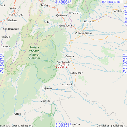
Cubarral GPS coordinates[2]
3° 47' 43.296" North, 73° 50' 26.268" West
| Map corner | latitude | longitude |
|---|---|---|
| Upper-left | 4.49664°, | -74.54376° |
| Center: | 3.79536°, | -73.84063° |
| Lower-right: | 3.09351°, | -73.13751° |
| Map W x H: | 156×156 km | = 96.9×96.9mi |
| max Lat: | 13.38166° ⇑79.6% North |
| Cubarral: | 3.79536° |
| min Lat: | ⇓20.4% South -4.21528° |
| min Long | Cubarral | max Long |
| -81.70636° | -73.84063° | -67.06996° |
| W 68.7%⇐ | ⇒31.3% E |
Elevation
Elevation of Cubarral is 589 m = 1932 ft, and this is 560.3 m = 1838 ft below average elevation for this country.
| Max E: |
3342 m = 10965 ft | 62.4% |
| Avg. | 1149.3 m = 3771 ft | |
| Cubarral | 589 m = 1932 ft | |
Min E: |
1 m = 3 ft | 37.6% |
See also: Colombia elevation on elevation.city.
Geographical zone
Cubarral is located in North Torrid zone (between Equator and Tropic of Cancer). Distance of Equator is 422 km =262.2 mi to South.| Distance of | km | miles | from Cubarral |
|---|---|---|---|
| North Pole | 9585.1 | 5955.9 | to North |
| Arctic Circle | 6979.2 | 4336.7 | to North |
| Tropic Cancer | 2183.9 | 1357 | to North |
| Equator | 422 | 262.2 | to South |


Nearby cities:
15 places around Cubarral: (largest is in red/bold)
• Acacías
23.2 km =14.4 mi,  23°
23°
• Castilla La Nueva
17.3 km =10.7 mi,  78°
78°
• El Castillo
26.3 km =16.3 mi,  168°
168°
• El Dorado
6.3 km =3.9 mi, 174°
• Fuente de Oro
44.3 km =27.5 mi,  146°
146°
• Granada
31.4 km =19.5 mi, 151°
• Guamal
12.6 km =7.8 mi,  41°
41°
• Guayabetal
46.7 km =29 mi,  3°
3°
• Gutiérrez
54.1 km =33.6 mi,  340°
340°
• Lejanías
36 km =22.4 mi,  214°
214°
• Mesetas
51 km =31.7 mi, 206°
• Quetame
59.8 km =37.2 mi,  357°
357°
• San Juan de Arama
47.4 km =29.5 mi,  184°
184°
• San Martín
19.1 km =11.9 mi,  125°
125°
• Villavicencio
45.3 km =28.1 mi,  31°
31°
Sources, notices
• [Note1] Compared only with cities in Colombia existing in our database
• [Src1] Map data: © OpenStreetMap contributors (CC-BY-SA)
• [Src2] Other city data from geonames.org with taken over terms of usage.
• [Src3] Geographical zone / Annual Mean Temperature by Robert A. Rohde @ Wikipedia
