El Calvario geodata
El Calvario (Meta) is a seat of a second-order administrative division; located in Colombia in America/Bogota (GMT-5) time zone. With population of 557 people, there are 1022 cities with bigger population in this country. Compared to other cities in Colombia, 73.6% of cities are located further ↑North; 71.3% of cities are located further ←West and 76.5% of cities have lower elevation than El Calvario. Note1


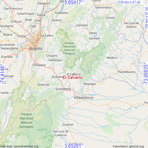
El Calvario GPS coordinates[2]
4° 21' 12.312" North, 73° 42' 41.292" West
| Map corner | latitude | longitude |
|---|---|---|
| Upper-left | 5.05417°, | -74.4146° |
| Center: | 4.35342°, | -73.71147° |
| Lower-right: | 3.65201°, | -73.00835° |
| Map W x H: | 155.9×155.9 km | = 96.9×96.9mi |
| max Lat: | 13.38166° ⇑73.6% North |
| El Calvario: | 4.35342° |
| min Lat: | ⇓26.4% South -4.21528° |
| min Long | El Calvario | max Long |
| -81.70636° | -73.71147° | -67.06996° |
| W 71.3%⇐ | ⇒28.7% E |
Elevation
Elevation of El Calvario is 1902 m = 6240 ft, and this is 752.7 m = 2469 ft above average elevation for this country.
| Max E: |
3342 m = 10965 ft | 23.5% |
| El Calvario | 1902 m 6240 ft | |
| Avg. | 1149.3 m = 3771 ft | |
Min E: |
1 m = 3 ft | 76.5% |
See also: Colombia elevation on elevation.city.
Geographical zone
El Calvario is located in North Torrid zone (between Equator and Tropic of Cancer). Distance of Equator is 484.1 km =300.8 mi to South.| Distance of | km | miles | from El Calvario |
|---|---|---|---|
| North Pole | 9523 | 5917.3 | to North |
| Arctic Circle | 6917.1 | 4298.1 | to North |
| Tropic Cancer | 2121.9 | 1318.5 | to North |
| Equator | 484.1 | 300.8 | to South |


Nearby cities:
15 places around El Calvario: (largest is in red/bold)
• Acacías
41.1 km =25.5 mi,  187°
187°
• Chipaque
38.2 km =23.7 mi,  285°
285°
• Choachí
30.5 km =19 mi,  309°
309°
• Cumaral
26.6 km =16.5 mi,  110°
110°
• Cáqueza
26.7 km =16.6 mi,  282°
282°
• Fosca
25.2 km =15.7 mi,  266°
266°
• Fómeque
25.5 km =15.8 mi, 305°
• Guayabetal
19.4 km =12.1 mi,  217°
217°
• Gutiérrez
34.1 km =21.2 mi,  251°
251°
• Quetame
16.8 km =10.4 mi,  261°
261°
• Restrepo
19.7 km =12.2 mi,  122°
122°
• San Juanito
12.4 km =7.7 mi,  16°
16°
• Ubaque
29.1 km =18.1 mi,  300°
300°
• Une
35.2 km =21.9 mi, 279°
• Villavicencio
25.3 km =15.7 mi,  158°
158°
Sources, notices
• [Note1] Compared only with cities in Colombia existing in our database
• [Src1] Map data: © OpenStreetMap contributors (CC-BY-SA)
• [Src2] Other city data from geonames.org with taken over terms of usage.
• [Src3] Geographical zone / Annual Mean Temperature by Robert A. Rohde @ Wikipedia
