Villavicencio geodata
Villavicencio (Meta) is a seat of a first-order administrative division; located in Colombia in America/Bogota (GMT-5) time zone. With population of 321,717 people, there are 15 cities with bigger population in this country. Compared to other cities in Colombia, 77.1% of cities are located further ↑North; 72.7% of cities are located further ←West and 64.9% of cities have higher elevation than Villavicencio. Note1


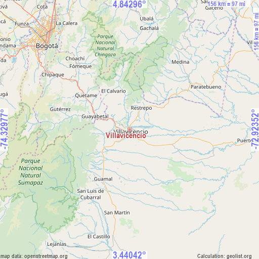
Villavicencio GPS coordinates[2]
4° 8' 31.2" North, 73° 37' 35.904" West
| Map corner | latitude | longitude |
|---|---|---|
| Upper-left | 4.84296°, | -74.32977° |
| Center: | 4.142°, | -73.62664° |
| Lower-right: | 3.44042°, | -72.92352° |
| Map W x H: | 155.9×156 km | = 96.9×96.9mi |
| max Lat: | 13.38166° ⇑77.1% North |
| Villavicencio: | 4.142° |
| min Lat: | ⇓22.9% South -4.21528° |
| min Long | Villavicencio | max Long |
| -81.70636° | -73.62664° | -67.06996° |
| W 72.7%⇐ | ⇒27.3% E |
Elevation
Elevation of Villavicencio is 441 m = 1447 ft, and this is 708.3 m = 2324 ft below average elevation for this country.
| Max E: |
3342 m = 10965 ft | 64.9% |
| Avg. | 1149.3 m = 3771 ft | |
| Villavicencio | 441 m = 1447 ft | |
Min E: |
1 m = 3 ft | 35.1% |
See also: Villavicencio elevation on elevation.city.
Geographical zone
Villavicencio is located in North Torrid zone (between Equator and Tropic of Cancer). Distance of Equator is 460.5 km =286.1 mi to South.| Distance of | km | miles | from Villavicencio |
|---|---|---|---|
| North Pole | 9546.5 | 5931.9 | to North |
| Arctic Circle | 6940.6 | 4312.7 | to North |
| Tropic Cancer | 2145.4 | 1333.1 | to North |
| Equator | 460.5 | 286.1 | to South |


Nearby cities:
15 places around Villavicencio: (largest is in red/bold)
• Acacías
22.6 km =14 mi,  220°
220°
• Castilla La Nueva
35.7 km =22.2 mi,  191°
191°
• Cubarral
45.3 km =28.1 mi,  211°
211°
• Cumaral
21.1 km =13.1 mi,  47°
47°
• Cáqueza
46 km =28.6 mi,  309°
309°
• El Calvario
25.3 km =15.7 mi,  338°
338°
• Fosca
40.9 km =25.4 mi,  302°
302°
• Fómeque
48.8 km =30.3 mi,  322°
322°
• Guamal
32.9 km =20.4 mi, 207°
• Guayabetal
22.6 km =14 mi,  290°
290°
• Gutiérrez
43.5 km =27 mi, 286°
• Quetame
33.6 km =20.9 mi, 309°
• Restrepo
14.8 km =9.2 mi,  29°
29°
• San Juanito
36 km =22.4 mi,  350°
350°
• San Martín
50.2 km =31.2 mi, 189°
Sources, notices
• [Note1] Compared only with cities in Colombia existing in our database
• [Src1] Map data: © OpenStreetMap contributors (CC-BY-SA)
• [Src2] Other city data from geonames.org with taken over terms of usage.
• [Src3] Geographical zone / Annual Mean Temperature by Robert A. Rohde @ Wikipedia
