San Carlos geodata
San Carlos (Antioquia) is a populated place; located in Colombia in America/Bogota (GMT-5) time zone. With population of 22,678 people, there are 160 cities with bigger population in this country. Compared to other cities in Colombia, 79.5% of cities are located further ↓South; 51.4% of cities are located further ←West and 85.1% of cities have higher elevation than San Carlos. Note1


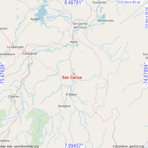
San Carlos GPS coordinates[2]
7° 47' 30.372" North, 74° 46' 23.376" West
| Map corner | latitude | longitude |
|---|---|---|
| Upper-left | 8.48781°, | -75.47629° |
| Center: | 7.79177°, | -74.77316° |
| Lower-right: | 7.09457°, | -74.07004° |
| Map W x H: | 154.9×154.9 km | = 96.3×96.3mi |
| max Lat: | 13.38166° ⇑20.5% North |
| San Carlos: | 7.79177° |
| min Lat: | ⇓79.5% South -4.21528° |
| min Long | San Carlos | max Long |
| -81.70636° | -74.77316° | -67.06996° |
| W 51.4%⇐ | ⇒48.6% E |
Elevation
Elevation of San Carlos is 59 m = 194 ft, and this is 1090.3 m = 3577 ft below average elevation for this country.
| Max E: |
3342 m = 10965 ft | 85.1% |
| Avg. | 1149.3 m = 3771 ft | |
| San Carlos | 59 m = 194 ft | |
Min E: |
1 m = 3 ft | 14.9% |
See also: Colombia elevation on elevation.city.
Geographical zone
San Carlos is located in North Torrid zone (between Equator and Tropic of Cancer). Distance of Equator is 866.4 km =538.4 mi to South.| Distance of | km | miles | from San Carlos |
|---|---|---|---|
| North Pole | 9140.7 | 5679.8 | to North |
| Arctic Circle | 6534.8 | 4060.5 | to North |
| Tropic Cancer | 1739.6 | 1080.9 | to North |
| Equator | 866.4 | 538.4 | to South |


Nearby cities:
15 places around San Carlos: (largest is in red/bold)
• Ayapel
70.7 km =43.9 mi,  325°
325°
• Caucasia
51.1 km =31.8 mi,  295°
295°
• Cruces de Anorí
75 km =46.6 mi,  205°
205°
• Cáceres
67.6 km =42 mi,  249°
249°
• El Bagre
21.3 km =13.2 mi,  190°
190°
• Guaranda
79.5 km =49.4 mi,  19°
19°
• La Apartada
68.4 km =42.5 mi,  294°
294°
• Montecristo
65.2 km =40.5 mi,  30°
30°
• Montelíbano
74.2 km =46.1 mi, 286°
• Nechí
33.6 km =20.9 mi,  359°
359°
• Pueblo Nuevo
54 km =33.6 mi,  337°
337°
• San Jacinto del Cauca
51.2 km =31.8 mi,  6°
6°
• Segovia
79.6 km =49.5 mi,  174°
174°
• Tarazá
72.9 km =45.3 mi, 251°
• Zaragoza
35.2 km =21.9 mi,  197°
197°
Sources, notices
• [Note1] Compared only with cities in Colombia existing in our database
• [Src1] Map data: © OpenStreetMap contributors (CC-BY-SA)
• [Src2] Other city data from geonames.org with taken over terms of usage.
• [Src3] Geographical zone / Annual Mean Temperature by Robert A. Rohde @ Wikipedia
