Turrialba geodata
Turrialba (Cartago) is a populated place; located in Costa Rica in America/Costa_Rica (GMT-6) time zone. With population of 28,955 people, there are 13 cities with bigger population in this country. Compared to other cities in Costa Rica, 67.9% of cities are located further ↑North; 86.6% of cities are located further ←West and 56.7% of cities have higher elevation than Turrialba. Note1


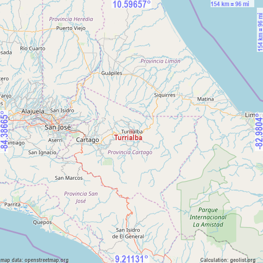
Turrialba GPS coordinates[2]
9° 54' 16.812" North, 83° 41' 0.672" West
| Map corner | latitude | longitude |
|---|---|---|
| Upper-left | 10.59657°, | -84.38665° |
| Center: | 9.90467°, | -83.68352° |
| Lower-right: | 9.21131°, | -82.9804° |
| Map W x H: | 154×154 km | = 95.7×95.7mi |
| max Lat: | 11.07377° ⇑67.9% North |
| Turrialba: | 9.90467° |
| min Lat: | ⇓32.1% South 8.53305° |
| min Long | Turrialba | max Long |
| -85.64748° | -83.68352° | -82.62185° |
| W 86.6%⇐ | ⇒13.4% E |
Elevation
Elevation of Turrialba is 648 m = 2126 ft, and this is 87 m = 285 ft below average elevation for this country.
| Max E: |
1844 m = 6050 ft | 56.7% |
| Avg. | 735 m = 2411 ft | |
| Turrialba | 648 m = 2126 ft | |
Min E: |
7 m = 23 ft | 43.3% |
See also: Costa Rica elevation on elevation.city.
Geographical zone
Turrialba is located in North Torrid zone (between Equator and Tropic of Cancer). Distance of Equator is 1101.3 km =684.3 mi to South.| Distance of | km | miles | from Turrialba |
|---|---|---|---|
| North Pole | 8905.8 | 5533.8 | to North |
| Arctic Circle | 6299.9 | 3914.6 | to North |
| Tropic Cancer | 1504.6 | 934.9 | to North |
| Equator | 1101.3 | 684.3 | to South |


Nearby cities:
15 places around Turrialba: (largest is in red/bold)
• Capellades
11.3 km =7 mi,  279°
279°
• Cartago
26.2 km =16.3 mi,  260°
260°
• Cot
20.8 km =12.9 mi,  266°
266°
• Guácimo
34.3 km =21.3 mi,  359°
359°
• Jiménez
30.9 km =19.2 mi,  341°
341°
• La Suiza
9.5 km =5.9 mi,  129°
129°
• Orosí
22.2 km =13.8 mi,  237°
237°
• Pacuarito
32.1 km =19.9 mi,  46°
46°
• Paraíso
21.3 km =13.2 mi,  249°
249°
• Pejibaye
10.6 km =6.6 mi,  191°
191°
• Pocora
30.9 km =19.2 mi,  16°
16°
• Siquirres
28.9 km =18 mi,  42°
42°
• Tobosi
33.7 km =20.9 mi, 257°
• Tres Ríos
33.3 km =20.7 mi, 270°
• Tucurrique
7.1 km =4.4 mi,  216°
216°
Sources, notices
• [Note1] Compared only with cities in Costa Rica existing in our database
• [Src1] Map data: © OpenStreetMap contributors (CC-BY-SA)
• [Src2] Other city data from geonames.org with taken over terms of usage.
• [Src3] Geographical zone / Annual Mean Temperature by Robert A. Rohde @ Wikipedia
