Pocora geodata
Pocora (Limón) is a populated place; located in Costa Rica in America/Costa_Rica (GMT-6) time zone. With population of 5,248 people, there are 74 cities with bigger population in this country. Compared to other cities in Costa Rica, 79.9% of cities are located further ↓South; 88.8% of cities are located further ←West and 79.1% of cities have higher elevation than Pocora. Note1


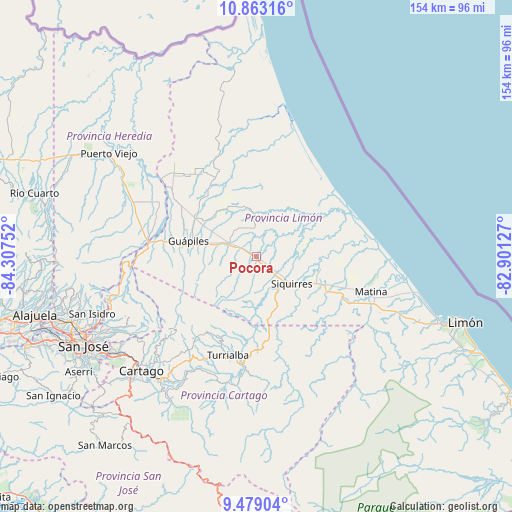
Pocora GPS coordinates[2]
10° 10' 18.66" North, 83° 36' 15.804" West
| Map corner | latitude | longitude |
|---|---|---|
| Upper-left | 10.86316°, | -84.30752° |
| Center: | 10.17185°, | -83.60439° |
| Lower-right: | 9.47904°, | -82.90127° |
| Map W x H: | 153.9×153.9 km | = 95.6×95.6mi |
| max Lat: | 11.07377° ⇑20.1% North |
| Pocora: | 10.17185° |
| min Lat: | ⇓79.9% South 8.53305° |
| min Long | Pocora | max Long |
| -85.64748° | -83.60439° | -82.62185° |
| W 88.8%⇐ | ⇒11.2% E |
Elevation
Elevation of Pocora is 99 m = 325 ft, and this is 636 m = 2087 ft below average elevation for this country.
| Max E: |
1844 m = 6050 ft | 79.1% |
| Avg. | 735 m = 2411 ft | |
| Pocora | 99 m = 325 ft | |
Min E: |
7 m = 23 ft | 20.9% |
See also: Costa Rica elevation on elevation.city.
Geographical zone
Pocora is located in North Torrid zone (between Equator and Tropic of Cancer). Distance of Equator is 1131 km =702.8 mi to South.| Distance of | km | miles | from Pocora |
|---|---|---|---|
| North Pole | 8876.1 | 5515.4 | to North |
| Arctic Circle | 6270.2 | 3896.1 | to North |
| Tropic Cancer | 1474.9 | 916.5 | to North |
| Equator | 1131 | 702.8 | to South |


Nearby cities:
15 places around Pocora: (largest is in red/bold)
• Batán
31.2 km =19.4 mi,  108°
108°
• Capellades
34.1 km =21.2 mi,  215°
215°
• Cariari
25.2 km =15.7 mi,  325°
325°
• Dulce Nombre de Jesus
40.9 km =25.4 mi,  266°
266°
• Guácimo
10.2 km =6.3 mi,  296°
296°
• Guápiles
20.4 km =12.7 mi,  284°
284°
• Jiménez
18.6 km =11.6 mi, 268°
• La Suiza
35.7 km =22.2 mi,  182°
182°
• Matina
36.4 km =22.6 mi, 105°
• Pacuarito
16.7 km =10.4 mi,  117°
117°
• Pejibaye
41.5 km =25.8 mi,  195°
195°
• Roxana
19.2 km =11.9 mi, 303°
• Siquirres
13.5 km =8.4 mi,  127°
127°
• Tucurrique
37.7 km =23.4 mi, 200°
• Turrialba
30.9 km =19.2 mi, 196°
Sources, notices
• [Note1] Compared only with cities in Costa Rica existing in our database
• [Src1] Map data: © OpenStreetMap contributors (CC-BY-SA)
• [Src2] Other city data from geonames.org with taken over terms of usage.
• [Src3] Geographical zone / Annual Mean Temperature by Robert A. Rohde @ Wikipedia
