Pejibaye geodata
Pejibaye (Cartago) is a populated place; located in Costa Rica in America/Costa_Rica (GMT-6) time zone. With population of 1,630 people, there are 109 cities with bigger population in this country. Compared to other cities in Costa Rica, 83.6% of cities are located further ↑North; 84.3% of cities are located further ←West and 55.2% of cities have higher elevation than Pejibaye. Note1


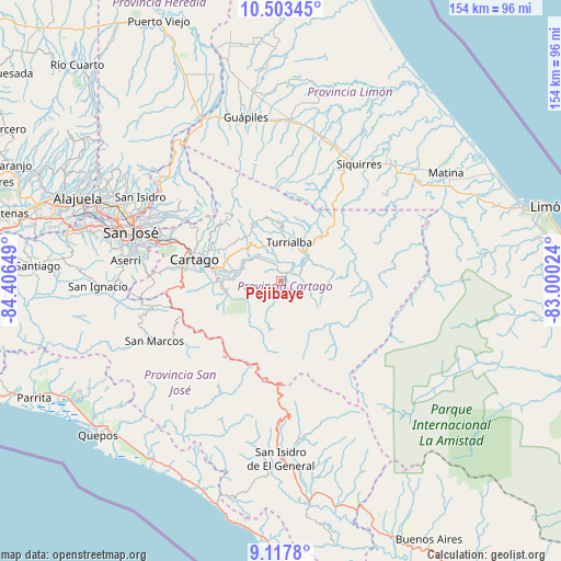
Pejibaye GPS coordinates[2]
9° 48' 40.86" North, 83° 42' 12.096" West
| Map corner | latitude | longitude |
|---|---|---|
| Upper-left | 10.50345°, | -84.40649° |
| Center: | 9.81135°, | -83.70336° |
| Lower-right: | 9.1178°, | -83.00024° |
| Map W x H: | 154.1×154.1 km | = 95.8×95.8mi |
| max Lat: | 11.07377° ⇑83.6% North |
| Pejibaye: | 9.81135° |
| min Lat: | ⇓16.4% South 8.53305° |
| min Long | Pejibaye | max Long |
| -85.64748° | -83.70336° | -82.62185° |
| W 84.3%⇐ | ⇒15.7% E |
Elevation
Elevation of Pejibaye is 652 m = 2139 ft, and this is 83 m = 272 ft below average elevation for this country.
| Max E: |
1844 m = 6050 ft | 55.2% |
| Avg. | 735 m = 2411 ft | |
| Pejibaye | 652 m = 2139 ft | |
Min E: |
7 m = 23 ft | 44.8% |
See also: Costa Rica elevation on elevation.city.
Geographical zone
Pejibaye is located in North Torrid zone (between Equator and Tropic of Cancer). Distance of Equator is 1090.9 km =677.9 mi to South.| Distance of | km | miles | from Pejibaye |
|---|---|---|---|
| North Pole | 8916.1 | 5540.2 | to North |
| Arctic Circle | 6310.3 | 3921 | to North |
| Tropic Cancer | 1515 | 941.4 | to North |
| Equator | 1090.9 | 677.9 | to South |


Nearby cities:
15 places around Pejibaye: (largest is in red/bold)
• Capellades
15.2 km =9.4 mi,  323°
323°
• Cartago
24.4 km =15.2 mi,  284°
284°
• Concepción
35.2 km =21.9 mi,  292°
292°
• Cot
20.8 km =12.9 mi,  296°
296°
• Granadilla
37 km =23 mi, 291°
• La Suiza
10.4 km =6.5 mi,  65°
65°
• Orosí
16.6 km =10.3 mi,  264°
264°
• Pacayas
37.7 km =23.4 mi,  269°
269°
• Paraíso
18 km =11.2 mi, 279°
• Patarrá
37.1 km =23.1 mi, 281°
• San Diego
34.2 km =21.3 mi, 286°
• Tobosi
30.9 km =19.2 mi, 275°
• Tres Ríos
32.9 km =20.4 mi, 288°
• Tucurrique
5.1 km =3.2 mi,  335°
335°
• Turrialba
10.6 km =6.6 mi,  11°
11°
Sources, notices
• [Note1] Compared only with cities in Costa Rica existing in our database
• [Src1] Map data: © OpenStreetMap contributors (CC-BY-SA)
• [Src2] Other city data from geonames.org with taken over terms of usage.
• [Src3] Geographical zone / Annual Mean Temperature by Robert A. Rohde @ Wikipedia
