Guácimo geodata
Guácimo (Limón) is a populated place; located in Costa Rica in America/Costa_Rica (GMT-6) time zone. With population of 7,022 people, there are 64 cities with bigger population in this country. Compared to other cities in Costa Rica, 82.1% of cities are located further ↓South; 85.8% of cities are located further ←West and 77.6% of cities have higher elevation than Guácimo. Note1


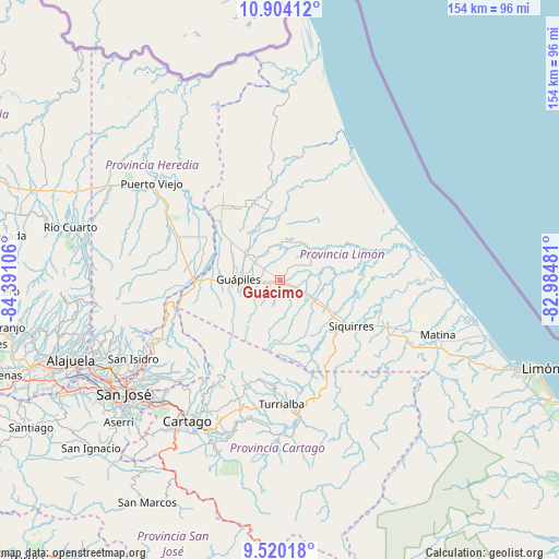
Guácimo GPS coordinates[2]
10° 12' 46.44" North, 83° 41' 16.548" West
| Map corner | latitude | longitude |
|---|---|---|
| Upper-left | 10.90412°, | -84.39106° |
| Center: | 10.2129°, | -83.68793° |
| Lower-right: | 9.52018°, | -82.98481° |
| Map W x H: | 153.9×153.9 km | = 95.6×95.6mi |
| max Lat: | 11.07377° ⇑17.9% North |
| Guácimo: | 10.2129° |
| min Lat: | ⇓82.1% South 8.53305° |
| min Long | Guácimo | max Long |
| -85.64748° | -83.68793° | -82.62185° |
| W 85.8%⇐ | ⇒14.2% E |
Elevation
Elevation of Guácimo is 120 m = 394 ft, and this is 615 m = 2018 ft below average elevation for this country.
| Max E: |
1844 m = 6050 ft | 77.6% |
| Avg. | 735 m = 2411 ft | |
| Guácimo | 120 m = 394 ft | |
Min E: |
7 m = 23 ft | 22.4% |
See also: Costa Rica elevation on elevation.city.
Geographical zone
Guácimo is located in North Torrid zone (between Equator and Tropic of Cancer). Distance of Equator is 1135.6 km =705.6 mi to South.| Distance of | km | miles | from Guácimo |
|---|---|---|---|
| North Pole | 8871.5 | 5512.5 | to North |
| Arctic Circle | 6265.6 | 3893.3 | to North |
| Tropic Cancer | 1470.4 | 913.7 | to North |
| Equator | 1135.6 | 705.6 | to South |


Nearby cities:
15 places around Guácimo: (largest is in red/bold)
• Batán
41.3 km =25.7 mi,  110°
110°
• Capellades
34.1 km =21.2 mi,  198°
198°
• Cariari
16.9 km =10.5 mi,  341°
341°
• Cot
40.8 km =25.4 mi,  209°
209°
• Dulce Nombre de Jesus
32.4 km =20.1 mi,  257°
257°
• Guápiles
10.6 km =6.6 mi,  272°
272°
• Jiménez
10.7 km =6.6 mi,  241°
241°
• La Suiza
41 km =25.5 mi,  169°
169°
• Pacuarito
26.9 km =16.7 mi,  117°
117°
• Pejibaye
44.7 km =27.8 mi,  182°
182°
• Pocora
10.2 km =6.3 mi, 116°
• Roxana
9.2 km =5.7 mi,  311°
311°
• Siquirres
23.6 km =14.7 mi, 122°
• Tucurrique
40.2 km =25 mi,  185°
185°
• Turrialba
34.3 km =21.3 mi, 179°
Sources, notices
• [Note1] Compared only with cities in Costa Rica existing in our database
• [Src1] Map data: © OpenStreetMap contributors (CC-BY-SA)
• [Src2] Other city data from geonames.org with taken over terms of usage.
• [Src3] Geographical zone / Annual Mean Temperature by Robert A. Rohde @ Wikipedia
