Sámara geodata
Sámara (Guanacaste) is a populated place; located in Costa Rica in America/Costa_Rica (GMT-6) time zone. With population of 1,071 people, there are 116 cities with bigger population in this country. Compared to other cities in Costa Rica, 70.9% of cities are located further ↑North; 97% of cities are located further →East and 96.3% of cities have higher elevation than Sámara. Note1


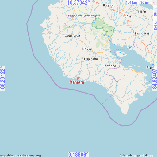
Sámara GPS coordinates[2]
9° 52' 53.292" North, 85° 31' 41.124" West
| Map corner | latitude | longitude |
|---|---|---|
| Upper-left | 10.57342°, | -86.23122° |
| Center: | 9.88147°, | -85.52809° |
| Lower-right: | 9.18806°, | -84.82497° |
| Map W x H: | 154×154 km | = 95.7×95.7mi |
| max Lat: | 11.07377° ⇑70.9% North |
| Sámara: | 9.88147° |
| min Lat: | ⇓29.1% South 8.53305° |
| min Long | Sámara | max Long |
| -85.64748° | -85.52809° | -82.62185° |
| W 3%⇐ | ⇒97% E |
Elevation
Elevation of Sámara is 10 m = 33 ft, and this is 725 m = 2379 ft below average elevation for this country.
| Max E: |
1844 m = 6050 ft | 96.3% |
| Avg. | 735 m = 2411 ft | |
| Sámara | 10 m = 33 ft | |
Min E: |
7 m = 23 ft | 3.7% |
See also: Costa Rica elevation on elevation.city.
Geographical zone
Sámara is located in North Torrid zone (between Equator and Tropic of Cancer). Distance of Equator is 1098.7 km =682.7 mi to South.| Distance of | km | miles | from Sámara |
|---|---|---|---|
| North Pole | 8908.3 | 5535.4 | to North |
| Arctic Circle | 6302.5 | 3916.2 | to North |
| Tropic Cancer | 1507.2 | 936.5 | to North |
| Equator | 1098.7 | 682.7 | to South |


Nearby cities:
15 places around Sámara: (largest is in red/bold)
• Bagaces
77.6 km =48.2 mi,  22°
22°
• Bejuco
22.1 km =13.7 mi,  99°
99°
• Belén
58.9 km =36.6 mi,  353°
353°
• Cañas
77.1 km =47.9 mi,  37°
37°
• Chacarita
82.8 km =51.4 mi,  82°
82°
• Hojancha
23 km =14.3 mi,  31°
31°
• Juntas
76.5 km =47.5 mi,  54°
54°
• Liberia
84.4 km =52.4 mi,  6°
6°
• Nandayure
39.7 km =24.7 mi,  64°
64°
• Nicoya
31.1 km =19.3 mi, 15°
• Paquera
65.3 km =40.6 mi, 96°
• Puntarenas
76.3 km =47.4 mi, 82°
• Santa Cruz
42.6 km =26.5 mi, 351°
• Sardinal
71.8 km =44.6 mi, 349°
• Zapotal
28.2 km =17.5 mi, 62°
Sources, notices
• [Note1] Compared only with cities in Costa Rica existing in our database
• [Src1] Map data: © OpenStreetMap contributors (CC-BY-SA)
• [Src2] Other city data from geonames.org with taken over terms of usage.
• [Src3] Geographical zone / Annual Mean Temperature by Robert A. Rohde @ Wikipedia
