Sardinal geodata
Sardinal (Guanacaste) is a populated place; located in Costa Rica in America/Costa_Rica (GMT-6) time zone. With population of 3,267 people, there are 93 cities with bigger population in this country. Compared to other cities in Costa Rica, 94% of cities are located further ↓South; 100% of cities are located further →East and 85.8% of cities have higher elevation than Sardinal. Note1


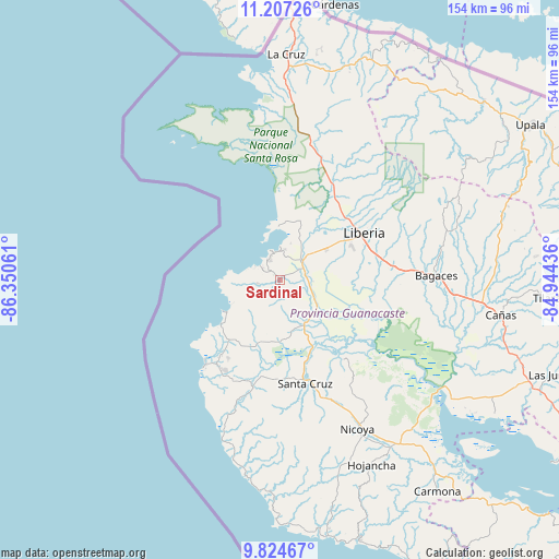
Sardinal GPS coordinates[2]
10° 31' 0.264" North, 85° 38' 50.928" West
| Map corner | latitude | longitude |
|---|---|---|
| Upper-left | 11.20726°, | -86.35061° |
| Center: | 10.51674°, | -85.64748° |
| Lower-right: | 9.82467°, | -84.94436° |
| Map W x H: | 153.7×153.7 km | = 95.5×95.5mi |
| max Lat: | 11.07377° ⇑6% North |
| Sardinal: | 10.51674° |
| min Lat: | ⇓94% South 8.53305° |
| min Long | Sardinal | max Long |
| -85.64748° | -85.64748° | -82.62185° |
| W 0%⇐ | ⇒100% E |
Elevation
Elevation of Sardinal is 50 m = 164 ft, and this is 685 m = 2247 ft below average elevation for this country.
| Max E: |
1844 m = 6050 ft | 85.8% |
| Avg. | 735 m = 2411 ft | |
| Sardinal | 50 m = 164 ft | |
Min E: |
7 m = 23 ft | 14.2% |
See also: Costa Rica elevation on elevation.city.
Geographical zone
Sardinal is located in North Torrid zone (between Equator and Tropic of Cancer). Distance of Equator is 1169.4 km =726.6 mi to South.| Distance of | km | miles | from Sardinal |
|---|---|---|---|
| North Pole | 8837.7 | 5491.5 | to North |
| Arctic Circle | 6231.8 | 3872.3 | to North |
| Tropic Cancer | 1436.6 | 892.7 | to North |
| Equator | 1169.4 | 726.6 | to South |


Nearby cities:
15 places around Sardinal: (largest is in red/bold)
• Bagaces
42.9 km =26.7 mi,  88°
88°
• Belén
13.7 km =8.5 mi,  151°
151°
• Bijagua
68.9 km =42.8 mi,  69°
69°
• Cañas
60.8 km =37.8 mi,  99°
99°
• Fortuna
51.9 km =32.2 mi, 70°
• Hojancha
56.9 km =35.4 mi, 153°
• La Cruz
62 km =38.5 mi,  1°
1°
• Liberia
26.4 km =16.4 mi,  60°
60°
• Nandayure
72.7 km =45.2 mi,  137°
137°
• Nicoya
46.1 km =28.6 mi, 152°
• San José
73.9 km =45.9 mi,  49°
49°
• Santa Cruz
29.3 km =18.2 mi,  166°
166°
• Sámara
71.8 km =44.6 mi, 169°
• Tilarán
74.5 km =46.3 mi, 94°
• Zapotal
68.9 km =42.8 mi, 146°
Sources, notices
• [Note1] Compared only with cities in Costa Rica existing in our database
• [Src1] Map data: © OpenStreetMap contributors (CC-BY-SA)
• [Src2] Other city data from geonames.org with taken over terms of usage.
• [Src3] Geographical zone / Annual Mean Temperature by Robert A. Rohde @ Wikipedia
