Nicoya geodata
Nicoya (Guanacaste) is a populated place; located in Costa Rica in America/Costa_Rica (GMT-6) time zone. With population of 15,313 people, there are 39 cities with bigger population in this country. Compared to other cities in Costa Rica, 77.6% of cities are located further ↓South; 96.3% of cities are located further →East and 76.9% of cities have higher elevation than Nicoya. Note1


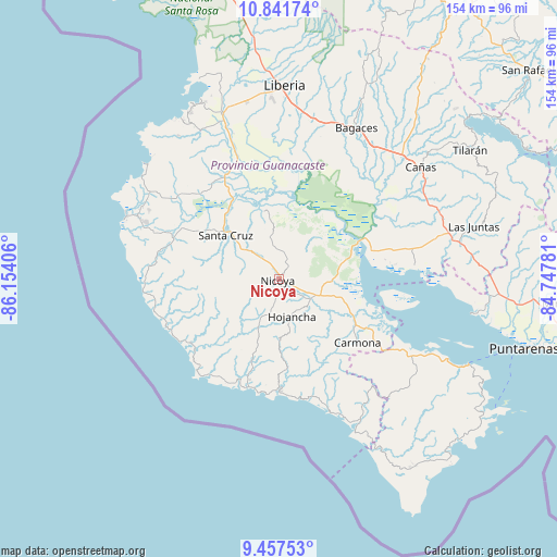
Nicoya GPS coordinates[2]
10° 9' 1.368" North, 85° 27' 3.348" West
| Map corner | latitude | longitude |
|---|---|---|
| Upper-left | 10.84174°, | -86.15406° |
| Center: | 10.15038°, | -85.45093° |
| Lower-right: | 9.45753°, | -84.74781° |
| Map W x H: | 153.9×153.9 km | = 95.6×95.6mi |
| max Lat: | 11.07377° ⇑22.4% North |
| Nicoya: | 10.15038° |
| min Lat: | ⇓77.6% South 8.53305° |
| min Long | Nicoya | max Long |
| -85.64748° | -85.45093° | -82.62185° |
| W 3.7%⇐ | ⇒96.3% E |
Elevation
Elevation of Nicoya is 128 m = 420 ft, and this is 607 m = 1991 ft below average elevation for this country.
| Max E: |
1844 m = 6050 ft | 76.9% |
| Avg. | 735 m = 2411 ft | |
| Nicoya | 128 m = 420 ft | |
Min E: |
7 m = 23 ft | 23.1% |
See also: Costa Rica elevation on elevation.city.
Geographical zone
Nicoya is located in North Torrid zone (between Equator and Tropic of Cancer). Distance of Equator is 1128.6 km =701.3 mi to South.| Distance of | km | miles | from Nicoya |
|---|---|---|---|
| North Pole | 8878.4 | 5516.8 | to North |
| Arctic Circle | 6272.6 | 3897.6 | to North |
| Tropic Cancer | 1477.3 | 918 | to North |
| Equator | 1128.6 | 701.3 | to South |


Nearby cities:
15 places around Nicoya: (largest is in red/bold)
• Bagaces
46.9 km =29.1 mi,  27°
27°
• Bejuco
35.9 km =22.3 mi,  158°
158°
• Belén
32.3 km =20.1 mi,  332°
332°
• Cañas
49.6 km =30.8 mi,  51°
51°
• Fortuna
64.4 km =40 mi, 25°
• Hojancha
10.9 km =6.8 mi, 160°
• Juntas
55.7 km =34.6 mi,  74°
74°
• Liberia
53.9 km =33.5 mi,  1°
1°
• Nandayure
30.4 km =18.9 mi,  115°
115°
• Paquera
67.4 km =41.9 mi, 123°
• Santa Cruz
19.1 km =11.9 mi,  309°
309°
• Sardinal
46.1 km =28.6 mi, 332°
• Sámara
31.1 km =19.3 mi,  195°
195°
• Tilarán
63.5 km =39.5 mi,  56°
56°
• Zapotal
23.5 km =14.6 mi,  135°
135°
Sources, notices
• [Note1] Compared only with cities in Costa Rica existing in our database
• [Src1] Map data: © OpenStreetMap contributors (CC-BY-SA)
• [Src2] Other city data from geonames.org with taken over terms of usage.
• [Src3] Geographical zone / Annual Mean Temperature by Robert A. Rohde @ Wikipedia
