Cañas geodata
Cañas (Guanacaste) is a populated place; located in Costa Rica in America/Costa_Rica (GMT-6) time zone. With population of 20,306 people, there are 32 cities with bigger population in this country. Compared to other cities in Costa Rica, 91% of cities are located further ↓South; 89.6% of cities are located further →East and 79.9% of cities have higher elevation than Cañas. Note1


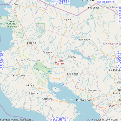
Cañas GPS coordinates[2]
10° 25' 51.78" North, 85° 5' 53.7" West
| Map corner | latitude | longitude |
|---|---|---|
| Upper-left | 11.12177°, | -85.80138° |
| Center: | 10.43105°, | -85.09825° |
| Lower-right: | 9.73879°, | -84.39513° |
| Map W x H: | 153.8×153.8 km | = 95.6×95.6mi |
| max Lat: | 11.07377° ⇑9% North |
| Cañas: | 10.43105° |
| min Lat: | ⇓91% South 8.53305° |
| min Long | Cañas | max Long |
| -85.64748° | -85.09825° | -82.62185° |
| W 10.4%⇐ | ⇒89.6% E |
Elevation
Elevation of Cañas is 86 m = 282 ft, and this is 649 m = 2129 ft below average elevation for this country.
| Max E: |
1844 m = 6050 ft | 79.9% |
| Avg. | 735 m = 2411 ft | |
| Cañas | 86 m = 282 ft | |
Min E: |
7 m = 23 ft | 20.1% |
See also: Costa Rica elevation on elevation.city.
Geographical zone
Cañas is located in North Torrid zone (between Equator and Tropic of Cancer). Distance of Equator is 1159.8 km =720.7 mi to South.| Distance of | km | miles | from Cañas |
|---|---|---|---|
| North Pole | 8847.2 | 5497.4 | to North |
| Arctic Circle | 6241.4 | 3878.2 | to North |
| Tropic Cancer | 1446.1 | 898.6 | to North |
| Equator | 1159.8 | 720.7 | to South |


Nearby cities:
15 places around Cañas: (largest is in red/bold)
• Bagaces
20.1 km =12.5 mi,  301°
301°
• Belén
53.7 km =33.4 mi,  267°
267°
• Bijagua
33.9 km =21.1 mi,  7°
7°
• Fortuna
29.2 km =18.1 mi,  337°
337°
• Hojancha
54.3 km =33.7 mi,  220°
220°
• Juntas
22.6 km =14 mi,  137°
137°
• La Fortuna
49.7 km =30.9 mi,  84°
84°
• Liberia
43.5 km =27 mi, 301°
• Miramar
55.2 km =34.3 mi,  133°
133°
• Nandayure
45.6 km =28.3 mi,  194°
194°
• Nicoya
49.6 km =30.8 mi,  231°
231°
• Pocosol
53.2 km =33.1 mi,  97°
97°
• Tilarán
14.8 km =9.2 mi,  74°
74°
• Upala
52.7 km =32.7 mi, 9°
• Zapotal
52.8 km =32.8 mi,  204°
204°
Sources, notices
• [Note1] Compared only with cities in Costa Rica existing in our database
• [Src1] Map data: © OpenStreetMap contributors (CC-BY-SA)
• [Src2] Other city data from geonames.org with taken over terms of usage.
• [Src3] Geographical zone / Annual Mean Temperature by Robert A. Rohde @ Wikipedia
