La Virgen geodata
La Virgen (Heredia) is a seat of a third-order administrative division; located in Costa Rica in America/Costa_Rica (GMT-6) time zone. In our database, there are 124 cities with bigger population. Compared to other cities in Costa Rica, 89.6% of cities are located further ↓South; 50.7% of cities are located further →East and 73.1% of cities have higher elevation than La Virgen. Note1


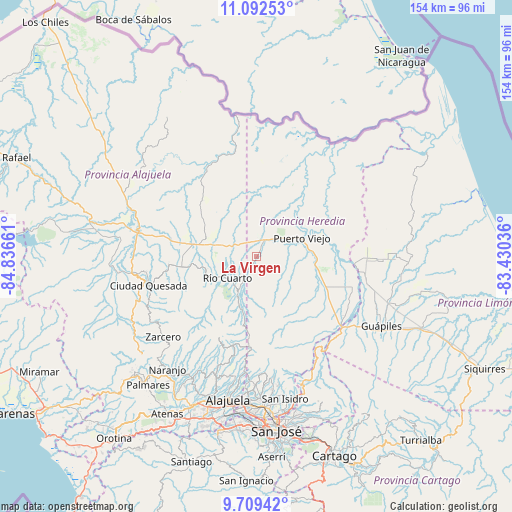
La Virgen GPS coordinates[2]
10° 24' 6.264" North, 84° 8' 0.528" West
| Map corner | latitude | longitude |
|---|---|---|
| Upper-left | 11.09253°, | -84.83661° |
| Center: | 10.40174°, | -84.13348° |
| Lower-right: | 9.70942°, | -83.43036° |
| Map W x H: | 153.8×153.8 km | = 95.6×95.6mi |
| max Lat: | 11.07377° ⇑10.4% North |
| La Virgen: | 10.40174° |
| min Lat: | ⇓89.6% South 8.53305° |
| min Long | La Virgen | max Long |
| -85.64748° | -84.13348° | -82.62185° |
| W 49.3%⇐ | ⇒50.7% E |
Elevation
Elevation of La Virgen is 188 m = 617 ft, and this is 547 m = 1795 ft below average elevation for this country.
| Max E: |
1844 m = 6050 ft | 73.1% |
| Avg. | 735 m = 2411 ft | |
| La Virgen | 188 m = 617 ft | |
Min E: |
7 m = 23 ft | 26.9% |
See also: Costa Rica elevation on elevation.city.
Geographical zone
La Virgen is located in North Torrid zone (between Equator and Tropic of Cancer). Distance of Equator is 1156.6 km =718.7 mi to South.| Distance of | km | miles | from La Virgen |
|---|---|---|---|
| North Pole | 8850.5 | 5499.4 | to North |
| Arctic Circle | 6244.6 | 3880.2 | to North |
| Tropic Cancer | 1449.4 | 900.6 | to North |
| Equator | 1156.6 | 718.7 | to South |


Nearby cities:
15 places around La Virgen: (largest is in red/bold)
• Dulce Nombre de Jesus
32.6 km =20.3 mi,  148°
148°
• Florencia
37.6 km =23.4 mi,  263°
263°
• Guápiles
43.3 km =26.9 mi,  118°
118°
• Laguna
36.2 km =22.5 mi,  233°
233°
• Naranjo
43 km =26.7 mi,  218°
218°
• Pital
16.3 km =10.1 mi,  289°
289°
• Quesada
33.3 km =20.7 mi,  254°
254°
• Río Segundo
23.9 km =14.9 mi, 221°
• Sabanilla
37.5 km =23.3 mi,  193°
193°
• San Josecito
43 km =26.7 mi,  175°
175°
• San Juan
38.9 km =24.2 mi,  211°
211°
• San Rafael
43.4 km =27 mi, 175°
• Santo Domingo
37.6 km =23.4 mi, 183°
• Sarchí
41.9 km =26 mi, 214°
• Zarcero
37 km =23 mi, 229°
Sources, notices
• [Note1] Compared only with cities in Costa Rica existing in our database
• [Src1] Map data: © OpenStreetMap contributors (CC-BY-SA)
• [Src2] Other city data from geonames.org with taken over terms of usage.
• [Src3] Geographical zone / Annual Mean Temperature by Robert A. Rohde @ Wikipedia
