Quesada geodata
Quesada (Alajuela) is a populated place; located in Costa Rica in America/Costa_Rica (GMT-6) time zone. With population of 27,310 people, there are 17 cities with bigger population in this country. Compared to other cities in Costa Rica, 86.6% of cities are located further ↓South; 73.9% of cities are located further →East and 56% of cities have higher elevation than Quesada. Note1


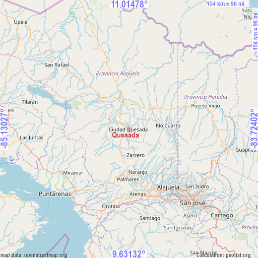
Quesada GPS coordinates[2]
10° 19' 25.716" North, 84° 25' 37.704" West
| Map corner | latitude | longitude |
|---|---|---|
| Upper-left | 11.01478°, | -85.13027° |
| Center: | 10.32381°, | -84.42714° |
| Lower-right: | 9.63132°, | -83.72402° |
| Map W x H: | 153.8×153.8 km | = 95.6×95.6mi |
| max Lat: | 11.07377° ⇑13.4% North |
| Quesada: | 10.32381° |
| min Lat: | ⇓86.6% South 8.53305° |
| min Long | Quesada | max Long |
| -85.64748° | -84.42714° | -82.62185° |
| W 26.1%⇐ | ⇒73.9% E |
Elevation
Elevation of Quesada is 651 m = 2136 ft, and this is 84 m = 276 ft below average elevation for this country.
| Max E: |
1844 m = 6050 ft | 56% |
| Avg. | 735 m = 2411 ft | |
| Quesada | 651 m = 2136 ft | |
Min E: |
7 m = 23 ft | 44% |
See also: Costa Rica elevation on elevation.city.
Geographical zone
Quesada is located in North Torrid zone (between Equator and Tropic of Cancer). Distance of Equator is 1147.9 km =713.3 mi to South.| Distance of | km | miles | from Quesada |
|---|---|---|---|
| North Pole | 8859.2 | 5504.8 | to North |
| Arctic Circle | 6253.3 | 3885.6 | to North |
| Tropic Cancer | 1458 | 906 | to North |
| Equator | 1147.9 | 713.3 | to South |


Nearby cities:
15 places around Quesada: (largest is in red/bold)
• Esquipulas
29.7 km =18.5 mi,  179°
179°
• Florencia
6.7 km =4.2 mi,  308°
308°
• La Fortuna
28.9 km =18 mi,  304°
304°
• La Virgen
33.3 km =20.7 mi,  74°
74°
• Laguna
13 km =8.1 mi,  167°
167°
• Naranjo
25.6 km =15.9 mi, 167°
• Pital
21.9 km =13.6 mi,  49°
49°
• Pocosol
21.3 km =13.2 mi,  282°
282°
• Río Segundo
18.6 km =11.6 mi,  119°
119°
• San Juan
27.4 km =17 mi,  153°
153°
• San Rafael
29.3 km =18.2 mi,  189°
189°
• San Ramón
26.6 km =16.5 mi, 190°
• Santiago
33.5 km =20.8 mi, 183°
• Sarchí
27.5 km =17.1 mi,  161°
161°
• Zarcero
15.9 km =9.9 mi, 165°
Sources, notices
• [Note1] Compared only with cities in Costa Rica existing in our database
• [Src1] Map data: © OpenStreetMap contributors (CC-BY-SA)
• [Src2] Other city data from geonames.org with taken over terms of usage.
• [Src3] Geographical zone / Annual Mean Temperature by Robert A. Rohde @ Wikipedia
