Moa geodata
Moa (Holguín) is a seat of a second-order administrative division; located in Cuba in America/Havana (GMT-4) time zone. With population of 92,852 people, there are 26 cities with bigger population in this country. Compared to other cities in Cuba, 82.9% of cities are located further ↑North; 97.2% of cities are located further ←West and 64.6% of cities have higher elevation than Moa. Note1


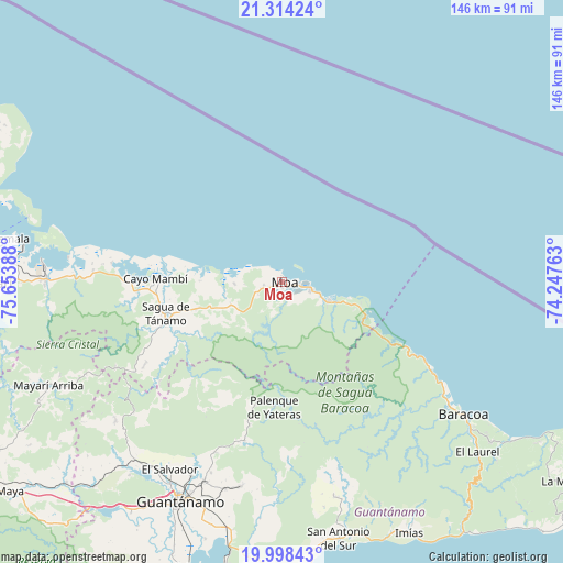
Moa GPS coordinates[2]
20° 39' 27.936" North, 74° 57' 2.7" West
| Map corner | latitude | longitude |
|---|---|---|
| Upper-left | 21.31424°, | -75.65388° |
| Center: | 20.65776°, | -74.95075° |
| Lower-right: | 19.99843°, | -74.24763° |
| Map W x H: | 146.3×146.3 km | = 90.9×90.9mi |
| max Lat: | 23.15917° ⇑82.9% North |
| Moa: | 20.65776° |
| min Lat: | ⇓17.1% South 19.90553° |
| min Long | Moa | max Long |
| -84.28599° | -74.95075° | -74.15181° |
| W 97.2%⇐ | ⇒2.8% E |
Elevation
Elevation of Moa is 31 m = 102 ft, and this is 37.6 m = 123 ft below average elevation for this country.
| Max E: |
761 m = 2497 ft | 64.6% |
| Avg. | 68.6 m = 225 ft | |
| Moa | 31 m = 102 ft | |
Min E: |
3 m = 10 ft | 35.4% |
See also: Moa elevation on elevation.city.
Geographical zone
Moa is located in North Torrid zone (between Equator and Tropic of Cancer). Distance of this Northern Tropic circle is 309 km =192 mi to North.| Distance of | km | miles | from Moa |
|---|---|---|---|
| North Pole | 7710.1 | 4790.8 | to North |
| Arctic Circle | 5104.2 | 3171.6 | to North |
| Tropic Cancer | 309 | 192 | to North |
| Equator | 2296.9 | 1427.2 | to South |


Nearby cities:
15 places around Moa: (largest is in red/bold)
• Antilla
83.9 km =52.1 mi,  283°
283°
• Banes
87 km =54.1 mi,  292°
292°
• Baracoa
58.6 km =36.4 mi,  126°
126°
• Cayo Mambí
33.1 km =20.6 mi,  271°
271°
• Cueto
101.9 km =63.3 mi, 269°
• Guantánamo
63.1 km =39.2 mi,  205°
205°
• Imías
73.4 km =45.6 mi,  153°
153°
• La Máquina
91.5 km =56.9 mi,  124°
124°
• Maisí
95 km =59 mi, 118°
• Mayarí
75.8 km =47.1 mi, 269°
• Palenque
32.8 km =20.4 mi,  183°
183°
• Río Guayabal de Yateras
33.1 km =20.6 mi,  191°
191°
• Sagua de Tánamo
31.4 km =19.5 mi,  254°
254°
• San Antonio del Sur
68.3 km =42.4 mi,  167°
167°
• Segundo Frente
63 km =39.1 mi,  244°
244°
Sources, notices
• [Note1] Compared only with cities in Cuba existing in our database
• [Src1] Map data: © OpenStreetMap contributors (CC-BY-SA)
• [Src2] Other city data from geonames.org with taken over terms of usage.
• [Src3] Geographical zone / Annual Mean Temperature by Robert A. Rohde @ Wikipedia
