Banes geodata
Banes (Holguín) is a seat of a second-order administrative division; located in Cuba in America/Havana (GMT-4) time zone. With population of 53,104 people, there are 44 cities with bigger population in this country. Compared to other cities in Cuba, 77.3% of cities are located further ↑North; 92.8% of cities are located further ←West and 61.3% of cities have higher elevation than Banes. Note1


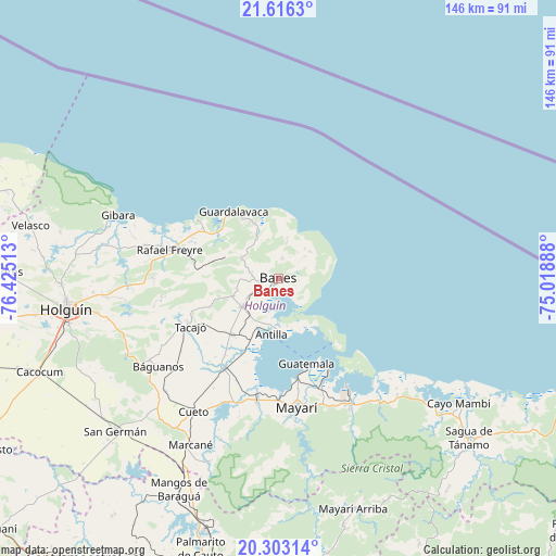
Banes GPS coordinates[2]
20° 57' 40.176" North, 75° 43' 19.2" West
| Map corner | latitude | longitude |
|---|---|---|
| Upper-left | 21.6163°, | -76.42513° |
| Center: | 20.96116°, | -75.722° |
| Lower-right: | 20.30314°, | -75.01888° |
| Map W x H: | 146×146 km | = 90.7×90.7mi |
| max Lat: | 23.15917° ⇑77.3% North |
| Banes: | 20.96116° |
| min Lat: | ⇓22.7% South 19.90553° |
| min Long | Banes | max Long |
| -84.28599° | -75.722° | -74.15181° |
| W 92.8%⇐ | ⇒7.2% E |
Elevation
Elevation of Banes is 36 m = 118 ft, and this is 32.6 m = 107 ft below average elevation for this country.
| Max E: |
761 m = 2497 ft | 61.3% |
| Avg. | 68.6 m = 225 ft | |
| Banes | 36 m = 118 ft | |
Min E: |
3 m = 10 ft | 38.7% |
See also: Banes elevation on elevation.city.
Geographical zone
Banes is located in North Torrid zone (between Equator and Tropic of Cancer). Distance of this Northern Tropic circle is 275.3 km =171.1 mi to North.| Distance of | km | miles | from Banes |
|---|---|---|---|
| North Pole | 7676.4 | 4769.9 | to North |
| Arctic Circle | 5070.5 | 3150.7 | to North |
| Tropic Cancer | 275.3 | 171.1 | to North |
| Equator | 2330.7 | 1448.2 | to South |


Nearby cities:
15 places around Banes: (largest is in red/bold)
• Antilla
14.5 km =9 mi,  185°
185°
• Báguanos
39.3 km =24.4 mi,  233°
233°
• Cacocum
67.5 km =41.9 mi,  248°
248°
• Cayo Mambí
57.5 km =35.7 mi,  125°
125°
• Cueto
40.9 km =25.4 mi,  211°
211°
• Gibara
45.6 km =28.3 mi,  291°
291°
• Holguín
56.8 km =35.3 mi,  261°
261°
• Jesús Menéndez
81.7 km =50.8 mi, 285°
• Jobabo
60 km =37.3 mi,  270°
270°
• Mayarí
34.4 km =21.4 mi,  172°
172°
• Moa
87 km =54.1 mi,  112°
112°
• Sagua de Tánamo
65.3 km =40.6 mi, 130°
• San Germán
58.7 km =36.5 mi, 226°
• Santa Lucía
29.3 km =18.2 mi, 285°
• Segundo Frente
65.2 km =40.5 mi,  158°
158°
Sources, notices
• [Note1] Compared only with cities in Cuba existing in our database
• [Src1] Map data: © OpenStreetMap contributors (CC-BY-SA)
• [Src2] Other city data from geonames.org with taken over terms of usage.
• [Src3] Geographical zone / Annual Mean Temperature by Robert A. Rohde @ Wikipedia
