Mayarí geodata
Mayarí (Holguín) is a seat of a second-order administrative division; located in Cuba in America/Havana (GMT-4) time zone. In our database, there are 154 cities with bigger population. Compared to other cities in Cuba, 83.4% of cities are located further ↑North; 93.4% of cities are located further ←West and 82.3% of cities have higher elevation than Mayarí. Note1


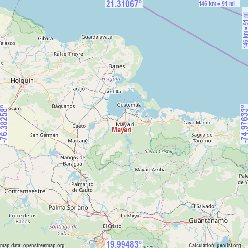
Mayarí GPS coordinates[2]
20° 39' 15.012" North, 75° 40' 46.02" West
| Map corner | latitude | longitude |
|---|---|---|
| Upper-left | 21.31067°, | -76.38258° |
| Center: | 20.65417°, | -75.67945° |
| Lower-right: | 19.99483°, | -74.97633° |
| Map W x H: | 146.3×146.3 km | = 90.9×90.9mi |
| max Lat: | 23.15917° ⇑83.4% North |
| Mayarí: | 20.65417° |
| min Lat: | ⇓16.6% South 19.90553° |
| min Long | Mayarí | max Long |
| -84.28599° | -75.67945° | -74.15181° |
| W 93.4%⇐ | ⇒6.6% E |
Elevation
Elevation of Mayarí is 19 m = 62 ft, and this is 49.6 m = 163 ft below average elevation for this country.
| Max E: |
761 m = 2497 ft | 82.3% |
| Avg. | 68.6 m = 225 ft | |
| Mayarí | 19 m = 62 ft | |
Min E: |
3 m = 10 ft | 17.7% |
See also: Cuba elevation on elevation.city.
Geographical zone
Mayarí is located in North Torrid zone (between Equator and Tropic of Cancer). Distance of this Northern Tropic circle is 309.4 km =192.3 mi to North.| Distance of | km | miles | from Mayarí |
|---|---|---|---|
| North Pole | 7710.5 | 4791.1 | to North |
| Arctic Circle | 5104.6 | 3171.9 | to North |
| Tropic Cancer | 309.4 | 192.3 | to North |
| Equator | 2296.5 | 1427 | to South |


Nearby cities:
15 places around Mayarí: (largest is in red/bold)
• Antilla
20.5 km =12.7 mi,  343°
343°
• Banes
34.4 km =21.4 mi,  352°
352°
• Báguanos
37.6 km =23.4 mi,  286°
286°
• Cacocum
67.9 km =42.2 mi,  277°
277°
• Cayo Mambí
42.7 km =26.5 mi,  88°
88°
• Contramaestre
70.9 km =44.1 mi,  236°
236°
• Cueto
26 km =16.2 mi,  268°
268°
• Gibara
69.1 km =42.9 mi,  317°
317°
• Holguín
66 km =41 mi, 293°
• Palma Soriano
59.1 km =36.7 mi,  213°
213°
• Sagua de Tánamo
46.3 km =28.8 mi,  99°
99°
• San Germán
47.6 km =29.6 mi,  262°
262°
• San Luis
54.8 km =34.1 mi,  198°
198°
• Santa Lucía
53 km =32.9 mi, 321°
• Segundo Frente
32.8 km =20.4 mi,  144°
144°
Sources, notices
• [Note1] Compared only with cities in Cuba existing in our database
• [Src1] Map data: © OpenStreetMap contributors (CC-BY-SA)
• [Src2] Other city data from geonames.org with taken over terms of usage.
• [Src3] Geographical zone / Annual Mean Temperature by Robert A. Rohde @ Wikipedia
