Guantánamo geodata
Guantánamo is a seat of a first-order administrative division; located in Cuba in America/Havana (GMT-4) time zone. With population of 272,801 people, there are 4 cities with bigger population in this country. Compared to other cities in Cuba, 96.1% of cities are located further ↑North; 95.6% of cities are located further ←West and 53.6% of cities have lower elevation than Guantánamo. Note1


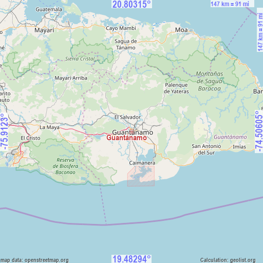
Guantánamo GPS coordinates[2]
20° 8' 39.984" North, 75° 12' 33.012" West
| Map corner | latitude | longitude |
|---|---|---|
| Upper-left | 20.80315°, | -75.9123° |
| Center: | 20.14444°, | -75.20917° |
| Lower-right: | 19.48294°, | -74.50605° |
| Map W x H: | 146.8×146.8 km | = 91.2×91.2mi |
| max Lat: | 23.15917° ⇑96.1% North |
| Guantánamo: | 20.14444° |
| min Lat: | ⇓3.9% South 19.90553° |
| min Long | Guantánamo | max Long |
| -84.28599° | -75.20917° | -74.15181° |
| W 95.6%⇐ | ⇒4.4% E |
Elevation
Elevation of Guantánamo is 56 m = 184 ft, and this is 12.6 m = 41 ft below average elevation for this country.
| Max E: |
761 m = 2497 ft | 46.4% |
| Avg. | 68.6 m = 225 ft | |
| Guantánamo | 56 m = 184 ft | |
Min E: |
3 m = 10 ft | 53.6% |
See also: Guantánamo elevation on elevation.city.
Geographical zone
Guantánamo is located in North Torrid zone (between Equator and Tropic of Cancer). Distance of this Northern Tropic circle is 366.1 km =227.5 mi to North.| Distance of | km | miles | from Guantánamo |
|---|---|---|---|
| North Pole | 7767.2 | 4826.3 | to North |
| Arctic Circle | 5161.3 | 3207.1 | to North |
| Tropic Cancer | 366.1 | 227.5 | to North |
| Equator | 2239.9 | 1391.8 | to South |


Nearby cities:
15 places around Guantánamo: (largest is in red/bold)
• Baracoa
77.7 km =48.3 mi,  73°
73°
• Cayo Mambí
58.1 km =36.1 mi,  353°
353°
• Cueto
93.7 km =58.2 mi,  306°
306°
• El Cobre
77.7 km =48.3 mi,  262°
262°
• Imías
60.9 km =37.8 mi,  97°
97°
• Mayarí
74.9 km =46.5 mi,  319°
319°
• Moa
63.1 km =39.2 mi,  25°
25°
• Palenque
34.9 km =21.7 mi,  45°
45°
• Palma Soriano
82.2 km =51.1 mi,  275°
275°
• Río Guayabal de Yateras
31.8 km =19.8 mi,  39°
39°
• Sagua de Tánamo
48.8 km =30.3 mi,  356°
356°
• San Antonio del Sur
42.7 km =26.5 mi, 103°
• San Luis
67.1 km =41.7 mi,  274°
274°
• Santiago de Cuba
65.9 km =40.9 mi, 257°
• Segundo Frente
42.4 km =26.3 mi, 315°
Sources, notices
• [Note1] Compared only with cities in Cuba existing in our database
• [Src1] Map data: © OpenStreetMap contributors (CC-BY-SA)
• [Src2] Other city data from geonames.org with taken over terms of usage.
• [Src3] Geographical zone / Annual Mean Temperature by Robert A. Rohde @ Wikipedia
