Maisí geodata
Maisí (Guantánamo) is a populated place; located in Cuba in America/Havana (GMT-4) time zone. With population of 28,276 people, there are 80 cities with bigger population in this country. Compared to other cities in Cuba, 92.3% of cities are located further ↑North; 100% of cities are located further ←West and 84% of cities have higher elevation than Maisí. Note1


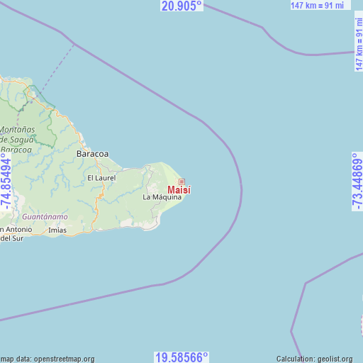
Maisí GPS coordinates[2]
20° 14' 48.228" North, 74° 9' 6.516" West
| Map corner | latitude | longitude |
|---|---|---|
| Upper-left | 20.905°, | -74.85494° |
| Center: | 20.24673°, | -74.15181° |
| Lower-right: | 19.58566°, | -73.44869° |
| Map W x H: | 146.7×146.7 km | = 91.2×91.2mi |
| max Lat: | 23.15917° ⇑92.3% North |
| Maisí: | 20.24673° |
| min Lat: | ⇓7.7% South 19.90553° |
| min Long | Maisí | max Long |
| -84.28599° | -74.15181° | -74.15181° |
| W 100%⇐ | ⇒0% E |
Elevation
Elevation of Maisí is 16 m = 52 ft, and this is 52.6 m = 173 ft below average elevation for this country.
| Max E: |
761 m = 2497 ft | 84% |
| Avg. | 68.6 m = 225 ft | |
| Maisí | 16 m = 52 ft | |
Min E: |
3 m = 10 ft | 16% |
See also: Cuba elevation on elevation.city.
Geographical zone
Maisí is located in North Torrid zone (between Equator and Tropic of Cancer). Distance of this Northern Tropic circle is 354.7 km =220.4 mi to North.| Distance of | km | miles | from Maisí |
|---|---|---|---|
| North Pole | 7755.8 | 4819.2 | to North |
| Arctic Circle | 5149.9 | 3200 | to North |
| Tropic Cancer | 354.7 | 220.4 | to North |
| Equator | 2251.2 | 1398.8 | to South |


Nearby cities:
15 places around Maisí: (largest is in red/bold)
• Antilla
177.2 km =110.1 mi,  291°
291°
• Baracoa
37.6 km =23.4 mi, 287°
• Cayo Mambí
125.3 km =77.9 mi, 291°
• Guantánamo
110.9 km =68.9 mi,  264°
264°
• Imías
53.8 km =33.4 mi,  248°
248°
• La Máquina
9.9 km =6.2 mi,  232°
232°
• Mayarí
165.5 km =102.8 mi, 285°
• Moa
95 km =59 mi,  298°
298°
• Palenque
86.3 km =53.6 mi,  278°
278°
• Río Guayabal de Yateras
91.2 km =56.7 mi, 278°
• Sagua de Tánamo
119.5 km =74.3 mi, 288°
• San Antonio del Sur
71.9 km =44.7 mi, 252°
• San Luis
177.3 km =110.2 mi,  267°
267°
• Santiago de Cuba
176.6 km =109.7 mi, 261°
• Segundo Frente
141.4 km =87.9 mi, 277°
Sources, notices
• [Note1] Compared only with cities in Cuba existing in our database
• [Src1] Map data: © OpenStreetMap contributors (CC-BY-SA)
• [Src2] Other city data from geonames.org with taken over terms of usage.
• [Src3] Geographical zone / Annual Mean Temperature by Robert A. Rohde @ Wikipedia
