Antilla geodata
Antilla (Holguín) is a seat of a second-order administrative division; located in Cuba in America/Havana (GMT-4) time zone. In our database, there are 154 cities with bigger population. Compared to other cities in Cuba, 79.6% of cities are located further ↑North; 92.3% of cities are located further ←West and 69.6% of cities have higher elevation than Antilla. Note1


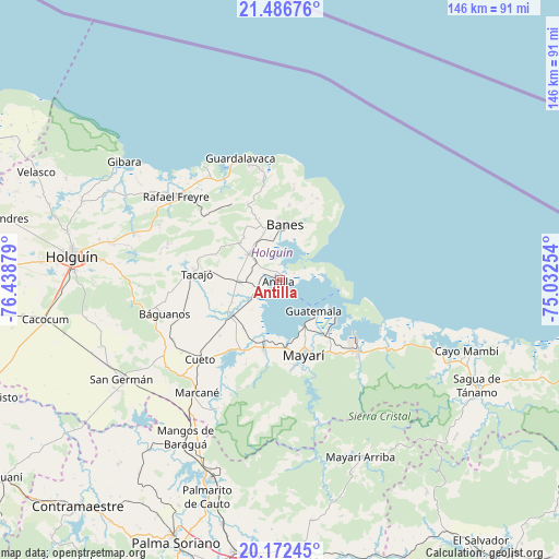
Antilla GPS coordinates[2]
20° 49' 51.744" North, 75° 44' 8.376" West
| Map corner | latitude | longitude |
|---|---|---|
| Upper-left | 21.48676°, | -76.43879° |
| Center: | 20.83104°, | -75.73566° |
| Lower-right: | 20.17245°, | -75.03254° |
| Map W x H: | 146.1×146.1 km | = 90.8×90.8mi |
| max Lat: | 23.15917° ⇑79.6% North |
| Antilla: | 20.83104° |
| min Lat: | ⇓20.4% South 19.90553° |
| min Long | Antilla | max Long |
| -84.28599° | -75.73566° | -74.15181° |
| W 92.3%⇐ | ⇒7.7% E |
Elevation
Elevation of Antilla is 27 m = 89 ft, and this is 41.6 m = 136 ft below average elevation for this country.
| Max E: |
761 m = 2497 ft | 69.6% |
| Avg. | 68.6 m = 225 ft | |
| Antilla | 27 m = 89 ft | |
Min E: |
3 m = 10 ft | 30.4% |
See also: Cuba elevation on elevation.city.
Geographical zone
Antilla is located in North Torrid zone (between Equator and Tropic of Cancer). Distance of this Northern Tropic circle is 289.7 km =180 mi to North.| Distance of | km | miles | from Antilla |
|---|---|---|---|
| North Pole | 7690.9 | 4778.9 | to North |
| Arctic Circle | 5085 | 3159.7 | to North |
| Tropic Cancer | 289.7 | 180 | to North |
| Equator | 2316.2 | 1439.2 | to South |


Nearby cities:
15 places around Antilla: (largest is in red/bold)
• Banes
14.5 km =9 mi,  5°
5°
• Báguanos
31.4 km =19.5 mi,  253°
253°
• Cacocum
62.2 km =38.6 mi,  260°
260°
• Cayo Mambí
52 km =32.3 mi,  110°
110°
• Cueto
28.6 km =17.8 mi,  224°
224°
• Gibara
51.5 km =32 mi,  307°
307°
• Holguín
55.2 km =34.3 mi,  276°
276°
• Jobabo
60.5 km =37.6 mi, 284°
• Mayarí
20.5 km =12.7 mi,  163°
163°
• Palma Soriano
74 km =46 mi,  201°
201°
• Sagua de Tánamo
58.4 km =36.3 mi,  118°
118°
• San Germán
48.7 km =30.3 mi,  238°
238°
• San Luis
72.5 km =45 mi,  189°
189°
• Santa Lucía
34.8 km =21.6 mi, 309°
• Segundo Frente
52.7 km =32.7 mi,  151°
151°
Sources, notices
• [Note1] Compared only with cities in Cuba existing in our database
• [Src1] Map data: © OpenStreetMap contributors (CC-BY-SA)
• [Src2] Other city data from geonames.org with taken over terms of usage.
• [Src3] Geographical zone / Annual Mean Temperature by Robert A. Rohde @ Wikipedia
