Segundo Frente geodata
Segundo Frente (Santiago de Cuba) is a seat of a second-order administrative division; located in Cuba in America/Havana (GMT-4) time zone. In our database, there are 154 cities with bigger population. Compared to other cities in Cuba, 86.7% of cities are located further ↑North; 93.9% of cities are located further ←West and 97.2% of cities have lower elevation than Segundo Frente. Note1


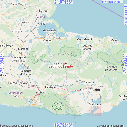
Segundo Frente GPS coordinates[2]
20° 24' 49.824" North, 75° 29' 46.86" West
| Map corner | latitude | longitude |
|---|---|---|
| Upper-left | 21.07138°, | -76.19948° |
| Center: | 20.41384°, | -75.49635° |
| Lower-right: | 19.75348°, | -74.79323° |
| Map W x H: | 146.5×146.5 km | = 91×91mi |
| max Lat: | 23.15917° ⇑86.7% North |
| Segundo Frente: | 20.41384° |
| min Lat: | ⇓13.3% South 19.90553° |
| min Long | Segundo Frente | max Long |
| -84.28599° | -75.49635° | -74.15181° |
| W 93.9%⇐ | ⇒6.1% E |
Elevation
Elevation of Segundo Frente is 221 m = 725 ft, and this is 152.4 m = 500 ft above average elevation for this country.
| Max E: |
761 m = 2497 ft | 2.8% |
| Segundo Frente | 221 m 725 ft | |
| Avg. | 68.6 m = 225 ft | |
Min E: |
3 m = 10 ft | 97.2% |
See also: Cuba elevation on elevation.city.
Geographical zone
Segundo Frente is located in North Torrid zone (between Equator and Tropic of Cancer). Distance of this Northern Tropic circle is 336.1 km =208.8 mi to North.| Distance of | km | miles | from Segundo Frente |
|---|---|---|---|
| North Pole | 7737.3 | 4807.7 | to North |
| Arctic Circle | 5131.4 | 3188.5 | to North |
| Tropic Cancer | 336.1 | 208.8 | to North |
| Equator | 2269.8 | 1410.4 | to South |


Nearby cities:
15 places around Segundo Frente: (largest is in red/bold)
• Antilla
52.7 km =32.7 mi,  331°
331°
• Banes
65.2 km =40.5 mi,  338°
338°
• Báguanos
66.6 km =41.4 mi,  304°
304°
• Cayo Mambí
36.5 km =22.7 mi,  40°
40°
• Cueto
52.1 km =32.4 mi, 300°
• El Cobre
62 km =38.5 mi,  229°
229°
• Guantánamo
42.4 km =26.3 mi,  135°
135°
• Mayarí
32.8 km =20.4 mi,  324°
324°
• Moa
63 km =39.1 mi,  64°
64°
• Palenque
55.1 km =34.2 mi,  95°
95°
• Palma Soriano
56.5 km =35.1 mi,  246°
246°
• Río Guayabal de Yateras
50.3 km =31.3 mi, 95°
• Sagua de Tánamo
32.5 km =20.2 mi,  54°
54°
• San Luis
44.6 km =27.7 mi,  235°
235°
• Santiago de Cuba
55.7 km =34.6 mi,  218°
218°
Sources, notices
• [Note1] Compared only with cities in Cuba existing in our database
• [Src1] Map data: © OpenStreetMap contributors (CC-BY-SA)
• [Src2] Other city data from geonames.org with taken over terms of usage.
• [Src3] Geographical zone / Annual Mean Temperature by Robert A. Rohde @ Wikipedia
