Cueto geodata
Cueto (Holguín) is a populated place; located in Cuba in America/Havana (GMT-4) time zone. With population of 26,527 people, there are 84 cities with bigger population in this country. Compared to other cities in Cuba, 84% of cities are located further ↑North; 90.6% of cities are located further ←West and 59.1% of cities have lower elevation than Cueto. Note1


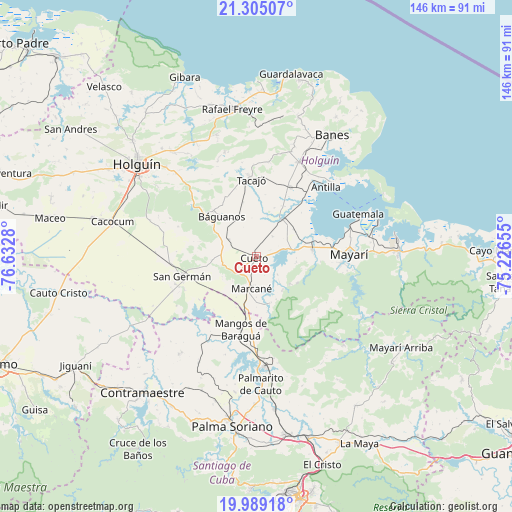
Cueto GPS coordinates[2]
20° 38' 54.78" North, 75° 55' 46.812" West
| Map corner | latitude | longitude |
|---|---|---|
| Upper-left | 21.30507°, | -76.6328° |
| Center: | 20.64855°, | -75.92967° |
| Lower-right: | 19.98918°, | -75.22655° |
| Map W x H: | 146.3×146.3 km | = 90.9×90.9mi |
| max Lat: | 23.15917° ⇑84% North |
| Cueto: | 20.64855° |
| min Lat: | ⇓16% South 19.90553° |
| min Long | Cueto | max Long |
| -84.28599° | -75.92967° | -74.15181° |
| W 90.6%⇐ | ⇒9.4% E |
Elevation
Elevation of Cueto is 61 m = 200 ft, and this is 7.6 m = 25 ft below average elevation for this country.
| Max E: |
761 m = 2497 ft | 40.9% |
| Avg. | 68.6 m = 225 ft | |
| Cueto | 61 m = 200 ft | |
Min E: |
3 m = 10 ft | 59.1% |
See also: Cuba elevation on elevation.city.
Geographical zone
Cueto is located in North Torrid zone (between Equator and Tropic of Cancer). Distance of this Northern Tropic circle is 310 km =192.6 mi to North.| Distance of | km | miles | from Cueto |
|---|---|---|---|
| North Pole | 7711.2 | 4791.5 | to North |
| Arctic Circle | 5105.3 | 3172.3 | to North |
| Tropic Cancer | 310 | 192.6 | to North |
| Equator | 2295.9 | 1426.6 | to South |


Nearby cities:
15 places around Cueto: (largest is in red/bold)
• Antilla
28.6 km =17.8 mi,  44°
44°
• Banes
40.9 km =25.4 mi,  31°
31°
• Báguanos
15.2 km =9.4 mi,  318°
318°
• Cacocum
42.4 km =26.3 mi,  283°
283°
• Cauto Cristo
57.4 km =35.7 mi,  259°
259°
• Contramaestre
50.9 km =31.6 mi,  220°
220°
• Gibara
55.4 km =34.4 mi,  337°
337°
• Holguín
43.7 km =27.2 mi,  307°
307°
• Jobabo
52.4 km =32.6 mi, 312°
• Mayarí
26 km =16.2 mi,  88°
88°
• Palma Soriano
49.1 km =30.5 mi,  187°
187°
• San Germán
21.9 km =13.6 mi, 255°
• San Luis
51.9 km =32.2 mi,  170°
170°
• Santa Lucía
42.9 km =26.7 mi,  350°
350°
• Segundo Frente
52.1 km =32.4 mi,  120°
120°
Sources, notices
• [Note1] Compared only with cities in Cuba existing in our database
• [Src1] Map data: © OpenStreetMap contributors (CC-BY-SA)
• [Src2] Other city data from geonames.org with taken over terms of usage.
• [Src3] Geographical zone / Annual Mean Temperature by Robert A. Rohde @ Wikipedia
