Baracoa geodata
Baracoa (Guantánamo) is a seat of a second-order administrative division; located in Cuba in America/Havana (GMT-4) time zone. With population of 48,362 people, there are 49 cities with bigger population in this country. Compared to other cities in Cuba, 89.5% of cities are located further ↑North; 98.9% of cities are located further ←West and 91.7% of cities have higher elevation than Baracoa. Note1


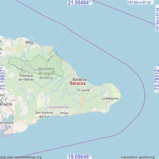
Baracoa GPS coordinates[2]
20° 20' 49.596" North, 74° 29' 46.464" West
| Map corner | latitude | longitude |
|---|---|---|
| Upper-left | 21.00494°, | -75.19937° |
| Center: | 20.34711°, | -74.49624° |
| Lower-right: | 19.68646°, | -73.79312° |
| Map W x H: | 146.6×146.6 km | = 91.1×91.1mi |
| max Lat: | 23.15917° ⇑89.5% North |
| Baracoa: | 20.34711° |
| min Lat: | ⇓10.5% South 19.90553° |
| min Long | Baracoa | max Long |
| -84.28599° | -74.49624° | -74.15181° |
| W 98.9%⇐ | ⇒1.1% E |
Elevation
Elevation of Baracoa is 12 m = 39 ft, and this is 56.6 m = 186 ft below average elevation for this country.
| Max E: |
761 m = 2497 ft | 91.7% |
| Avg. | 68.6 m = 225 ft | |
| Baracoa | 12 m = 39 ft | |
Min E: |
3 m = 10 ft | 8.3% |
See also: Baracoa elevation on elevation.city.
Geographical zone
Baracoa is located in North Torrid zone (between Equator and Tropic of Cancer). Distance of this Northern Tropic circle is 343.5 km =213.4 mi to North.| Distance of | km | miles | from Baracoa |
|---|---|---|---|
| North Pole | 7744.7 | 4812.3 | to North |
| Arctic Circle | 5138.8 | 3193.1 | to North |
| Tropic Cancer | 343.5 | 213.4 | to North |
| Equator | 2262.4 | 1405.8 | to South |


Nearby cities:
15 places around Baracoa: (largest is in red/bold)
• Antilla
139.8 km =86.9 mi,  292°
292°
• Cayo Mambí
87.8 km =54.6 mi, 293°
• Guantánamo
77.7 km =48.3 mi,  253°
253°
• Imías
34 km =21.1 mi,  204°
204°
• La Máquina
32.9 km =20.4 mi,  121°
121°
• Maisí
37.6 km =23.4 mi,  107°
107°
• Mayarí
127.9 km =79.5 mi, 285°
• Moa
58.6 km =36.4 mi,  306°
306°
• Palenque
49.5 km =30.8 mi,  272°
272°
• Río Guayabal de Yateras
54.3 km =33.7 mi, 272°
• Sagua de Tánamo
81.9 km =50.9 mi, 288°
• San Antonio del Sur
46 km =28.6 mi,  225°
225°
• San Luis
142.3 km =88.4 mi,  262°
262°
• Santiago de Cuba
143.5 km =89.2 mi, 255°
• Segundo Frente
104.5 km =64.9 mi, 274°
Sources, notices
• [Note1] Compared only with cities in Cuba existing in our database
• [Src1] Map data: © OpenStreetMap contributors (CC-BY-SA)
• [Src2] Other city data from geonames.org with taken over terms of usage.
• [Src3] Geographical zone / Annual Mean Temperature by Robert A. Rohde @ Wikipedia
