Santiago de Cuba geodata
Santiago de Cuba is a seat of a first-order administrative division; located in Cuba in America/Havana (GMT-4) time zone. With population of 555,865 people, there is 1 city with bigger population in this country. Compared to other cities in Cuba, 99.4% of cities are located further ↑North; 91.7% of cities are located further ←West and 54.1% of cities have higher elevation than Santiago de Cuba. Note1


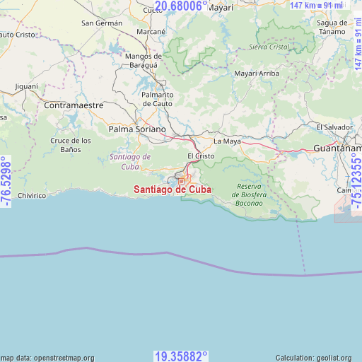
Santiago de Cuba GPS coordinates[2]
20° 1' 14.988" North, 75° 49' 36.012" West
| Map corner | latitude | longitude |
|---|---|---|
| Upper-left | 20.68006°, | -76.5298° |
| Center: | 20.02083°, | -75.82667° |
| Lower-right: | 19.35882°, | -75.12355° |
| Map W x H: | 146.9×146.9 km | = 91.3×91.3mi |
| max Lat: | 23.15917° ⇑99.4% North |
| Santiago de Cuba: | 20.02083° |
| min Lat: | ⇓0.6% South 19.90553° |
| min Long | Santiago de Cub | max Long |
| -84.28599° | -75.82667° | -74.15181° |
| W 91.7%⇐ | ⇒8.3% E |
Elevation
Elevation of Santiago de Cuba is 46 m = 151 ft, and this is 22.6 m = 74 ft below average elevation for this country.
| Max E: |
761 m = 2497 ft | 54.1% |
| Avg. | 68.6 m = 225 ft | |
| Santiago de Cuba | 46 m = 151 ft | |
Min E: |
3 m = 10 ft | 45.9% |
See also: Santiago de Cuba elevation on elevation.city.
Geographical zone
Santiago de Cuba is located in North Torrid zone (between Equator and Tropic of Cancer). Distance of this Northern Tropic circle is 379.8 km =236 mi to North.| Distance of | km | miles | from Santiago de Cuba |
|---|---|---|---|
| North Pole | 7781 | 4834.9 | to North |
| Arctic Circle | 5175.1 | 3215.7 | to North |
| Tropic Cancer | 379.8 | 236 | to North |
| Equator | 2226.1 | 1383.2 | to South |


Nearby cities:
15 places around Santiago de Cuba: (largest is in red/bold)
• Antilla
90.6 km =56.3 mi,  6°
6°
• Báguanos
83.8 km =52.1 mi,  345°
345°
• Cauto Cristo
90 km =55.9 mi,  311°
311°
• Contramaestre
53.5 km =33.2 mi, 305°
• Cueto
70.6 km =43.9 mi, 351°
• El Cobre
12.8 km =8 mi,  283°
283°
• Guantánamo
65.9 km =40.9 mi,  77°
77°
• Guisa
78.8 km =49 mi,  289°
289°
• Jiguaní
73.6 km =45.7 mi,  301°
301°
• Mayarí
72.1 km =44.8 mi, 12°
• Palma Soriano
27.4 km =17 mi,  320°
320°
• Sagua de Tánamo
87.4 km =54.3 mi,  44°
44°
• San Germán
71.9 km =44.7 mi,  333°
333°
• San Luis
18.8 km =11.7 mi, 352°
• Segundo Frente
55.7 km =34.6 mi, 38°
Sources, notices
• [Note1] Compared only with cities in Cuba existing in our database
• [Src1] Map data: © OpenStreetMap contributors (CC-BY-SA)
• [Src2] Other city data from geonames.org with taken over terms of usage.
• [Src3] Geographical zone / Annual Mean Temperature by Robert A. Rohde @ Wikipedia
