Mindelo geodata
Mindelo (São Vicente) is a seat of a first-order administrative division; located in Cape Verde in Atlantic/Cape_Verde (GMT-1) time zone. With population of 70,611 people, there is 1 city with bigger population in this country. Compared to other cities in Cape Verde, 83.3% of cities are located further ↓South; 83.3% of cities are located further →East and 54.2% of cities have lower elevation than Mindelo. Note1


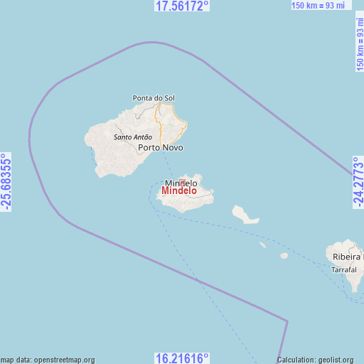
Mindelo GPS coordinates[2]
16° 53' 24.504" North, 24° 58' 49.512" West
| Map corner | latitude | longitude |
|---|---|---|
| Upper-left | 17.56172°, | -25.68355° |
| Center: | 16.89014°, | -24.98042° |
| Lower-right: | 16.21616°, | -24.2773° |
| Map W x H: | 149.6×149.6 km | = 93×93mi |
| max Lat: | 17.20171° ⇑16.7% North |
| Mindelo: | 16.89014° |
| min Lat: | ⇓83.3% South 14.87139° |
| min Long | Mindelo | max Long |
| -25.09217° | -24.98042° | -22.90509° |
| W 16.7%⇐ | ⇒83.3% E |
Elevation
Elevation of Mindelo is 44 m = 144 ft, and this is 73.8 m = 242 ft below average elevation for this country.
| Max E: |
480 m = 1575 ft | 45.8% |
| Avg. | 117.8 m = 386 ft | |
| Mindelo | 44 m = 144 ft | |
Min E: |
1 m = 3 ft | 54.2% |
See also: Mindelo elevation on elevation.city.
Geographical zone
Mindelo is located in North Torrid zone (between Equator and Tropic of Cancer). Distance of this Northern Tropic circle is 727.9 km =452.3 mi to North.| Distance of | km | miles | from Mindelo |
|---|---|---|---|
| North Pole | 8129.1 | 5051.2 | to North |
| Arctic Circle | 5523.2 | 3432 | to North |
| Tropic Cancer | 727.9 | 452.3 | to North |
| Equator | 1878 | 1166.9 | to South |


Nearby cities:
15 places around Mindelo: (largest is in red/bold)
• Calheta
240.6 km =149.5 mi,  141°
141°
• Cova Figueira
234.2 km =145.5 mi,  161°
161°
• Espargos
217.2 km =135 mi,  93°
93°
• Igreja
218 km =135.5 mi, 161°
• Nova Sintra
226.5 km =140.7 mi,  172°
172°
• Pombas
29.2 km =18.1 mi,  351°
351°
• Ponta do Sol
36.6 km =22.7 mi,  341°
341°
• Porto Novo
17 km =10.6 mi,  328°
328°
• Ribeira Brava
78.8 km =49 mi,  112°
112°
• Ribeira Grande
33.7 km =20.9 mi, 344°
• Sal Rei
233.8 km =145.3 mi, 109°
• Santa Maria
223.3 km =138.8 mi,  98°
98°
• São Filipe
227.7 km =141.5 mi, 166°
• Tarrafal
222.1 km =138 mi, 143°
• Tarrafal de São Nicolau
75.4 km =46.9 mi,  118°
118°
Sources, notices
• [Note1] Compared only with cities in Cape Verde existing in our database
• [Src1] Map data: © OpenStreetMap contributors (CC-BY-SA)
• [Src2] Other city data from geonames.org with taken over terms of usage.
• [Src3] Geographical zone / Annual Mean Temperature by Robert A. Rohde @ Wikipedia
