Sal Rei geodata
Sal Rei (Boa Vista) is a seat of a first-order administrative division; located in Cape Verde in Atlantic/Cape_Verde (GMT-1) time zone. With population of 2,122 people, there are 19 cities with bigger population in this country. Compared to other cities in Cape Verde, 62.5% of cities are located further ↓South; 95.8% of cities are located further ←West and 100% of cities have higher elevation than Sal Rei. Note1


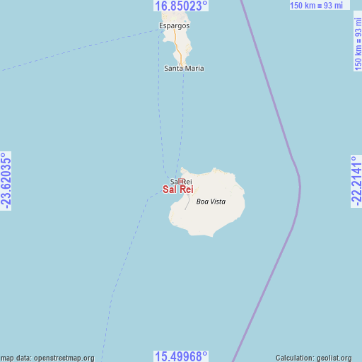
Sal Rei GPS coordinates[2]
16° 10' 33.996" North, 22° 55' 1.992" West
| Map corner | latitude | longitude |
|---|---|---|
| Upper-left | 16.85023°, | -23.62035° |
| Center: | 16.17611°, | -22.91722° |
| Lower-right: | 15.49968°, | -22.2141° |
| Map W x H: | 150.2×150.2 km | = 93.3×93.3mi |
| max Lat: | 17.20171° ⇑37.5% North |
| Sal Rei: | 16.17611° |
| min Lat: | ⇓62.5% South 14.87139° |
| min Long | Sal Rei | max Long |
| -25.09217° | -22.91722° | -22.90509° |
| W 95.8%⇐ | ⇒4.2% E |
Elevation
Elevation of Sal Rei is 1 m = 3 ft, and this is 116.8 m = 383 ft below average elevation for this country.
| Max E: |
480 m = 1575 ft | 100% |
| Avg. | 117.8 m = 386 ft | |
| Sal Rei | 1 m = 3 ft | |
Min E: |
1 m = 3 ft | 0% |
See also: Cape Verde elevation on elevation.city.
Geographical zone
Sal Rei is located in North Torrid zone (between Equator and Tropic of Cancer). Distance of this Northern Tropic circle is 807.3 km =501.6 mi to North.| Distance of | km | miles | from Sal Rei |
|---|---|---|---|
| North Pole | 8208.4 | 5100.5 | to North |
| Arctic Circle | 5602.6 | 3481.3 | to North |
| Tropic Cancer | 807.3 | 501.6 | to North |
| Equator | 1798.6 | 1117.6 | to South |


Nearby cities:
15 places around Sal Rei: (largest is in red/bold)
• Assomada
145.1 km =90.2 mi,  214°
214°
• Calheta
131.7 km =81.8 mi, 213°
• Cidade Velha
158.4 km =98.4 mi, 207°
• Espargos
64.5 km =40.1 mi,  357°
357°
• João Teves
142.8 km =88.7 mi, 210°
• Pedra Badejo
132.9 km =82.6 mi, 209°
• Picos
143.6 km =89.2 mi, 212°
• Praia
152.4 km =94.7 mi,  204°
204°
• Ribeira Brava
155.2 km =96.4 mi,  288°
288°
• Santa Cruz
135.2 km =84 mi, 210°
• Santa Maria
46.9 km =29.1 mi,  1°
1°
• São Domingos
145.5 km =90.4 mi, 208°
• Tarrafal
133.9 km =83.2 mi,  221°
221°
• Tarrafal de São Nicolau
159.7 km =99.2 mi, 285°
• Vila do Maio
119.6 km =74.3 mi, 195°
Sources, notices
• [Note1] Compared only with cities in Cape Verde existing in our database
• [Src1] Map data: © OpenStreetMap contributors (CC-BY-SA)
• [Src2] Other city data from geonames.org with taken over terms of usage.
• [Src3] Geographical zone / Annual Mean Temperature by Robert A. Rohde @ Wikipedia
