Calheta geodata
Calheta (São Miguel) is a seat of a first-order administrative division; located in Cape Verde in Atlantic/Cape_Verde (GMT-1) time zone. With population of 5,400 people, there are 11 cities with bigger population in this country. Compared to other cities in Cape Verde, 54.2% of cities are located further ↓South; 62.5% of cities are located further ←West and 83.3% of cities have higher elevation than Calheta. Note1


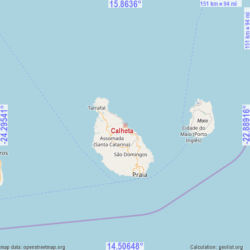
Calheta GPS coordinates[2]
15° 11' 10.068" North, 23° 35' 32.208" West
| Map corner | latitude | longitude |
|---|---|---|
| Upper-left | 15.8636°, | -24.29541° |
| Center: | 15.18613°, | -23.59228° |
| Lower-right: | 14.50648°, | -22.88916° |
| Map W x H: | 150.9×150.9 km | = 93.8×93.8mi |
| max Lat: | 17.20171° ⇑45.8% North |
| Calheta: | 15.18613° |
| min Lat: | ⇓54.2% South 14.87139° |
| min Long | Calheta | max Long |
| -25.09217° | -23.59228° | -22.90509° |
| W 62.5%⇐ | ⇒37.5% E |
Elevation
Elevation of Calheta is 7 m = 23 ft, and this is 110.8 m = 364 ft below average elevation for this country.
| Max E: |
480 m = 1575 ft | 83.3% |
| Avg. | 117.8 m = 386 ft | |
| Calheta | 7 m = 23 ft | |
Min E: |
1 m = 3 ft | 16.7% |
See also: Cape Verde elevation on elevation.city.
Geographical zone
Calheta is located in North Torrid zone (between Equator and Tropic of Cancer). Distance of this Northern Tropic circle is 917.4 km =570 mi to North.| Distance of | km | miles | from Calheta |
|---|---|---|---|
| North Pole | 8318.5 | 5168.9 | to North |
| Arctic Circle | 5712.6 | 3549.6 | to North |
| Tropic Cancer | 917.4 | 570 | to North |
| Equator | 1688.5 | 1049.2 | to South |


Nearby cities:
15 places around Calheta: (largest is in red/bold)
• Assomada
13.7 km =8.5 mi,  225°
225°
• Cidade Velha
30.1 km =18.7 mi,  182°
182°
• Cova Figueira
82.2 km =51.1 mi,  246°
246°
• Igreja
80.5 km =50 mi,  257°
257°
• João Teves
13.3 km =8.3 mi, 178°
• Nova Sintra
123.5 km =76.7 mi, 253°
• Pedra Badejo
8.5 km =5.3 mi,  129°
129°
• Picos
12.2 km =7.6 mi,  200°
200°
• Praia
29.6 km =18.4 mi,  163°
163°
• Sal Rei
131.7 km =81.8 mi,  33°
33°
• Santa Cruz
6.5 km =4 mi,  154°
154°
• São Domingos
18.3 km =11.4 mi,  169°
169°
• São Filipe
102.2 km =63.5 mi, 251°
• Tarrafal
20 km =12.4 mi,  301°
301°
• Vila do Maio
41.2 km =25.6 mi,  97°
97°
Sources, notices
• [Note1] Compared only with cities in Cape Verde existing in our database
• [Src1] Map data: © OpenStreetMap contributors (CC-BY-SA)
• [Src2] Other city data from geonames.org with taken over terms of usage.
• [Src3] Geographical zone / Annual Mean Temperature by Robert A. Rohde @ Wikipedia
