Espargos geodata
Espargos (Sal) is a seat of a first-order administrative division; located in Cape Verde in Atlantic/Cape_Verde (GMT-1) time zone. With population of 6,173 people, there are 9 cities with bigger population in this country. Compared to other cities in Cape Verde, 79.2% of cities are located further ↓South; 91.7% of cities are located further ←West and 62.5% of cities have lower elevation than Espargos. Note1


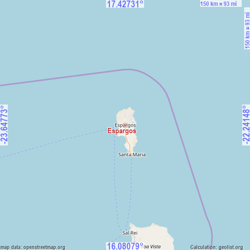
Espargos GPS coordinates[2]
16° 45' 18.864" North, 22° 56' 40.56" West
| Map corner | latitude | longitude |
|---|---|---|
| Upper-left | 17.42731°, | -23.64773° |
| Center: | 16.75524°, | -22.9446° |
| Lower-right: | 16.08079°, | -22.24148° |
| Map W x H: | 149.7×149.7 km | = 93×93mi |
| max Lat: | 17.20171° ⇑20.8% North |
| Espargos: | 16.75524° |
| min Lat: | ⇓79.2% South 14.87139° |
| min Long | Espargos | max Long |
| -25.09217° | -22.9446° | -22.90509° |
| W 91.7%⇐ | ⇒8.3% E |
Elevation
Elevation of Espargos is 53 m = 174 ft, and this is 64.8 m = 213 ft below average elevation for this country.
| Max E: |
480 m = 1575 ft | 37.5% |
| Avg. | 117.8 m = 386 ft | |
| Espargos | 53 m = 174 ft | |
Min E: |
1 m = 3 ft | 62.5% |
See also: Cape Verde elevation on elevation.city.
Geographical zone
Espargos is located in North Torrid zone (between Equator and Tropic of Cancer). Distance of this Northern Tropic circle is 742.9 km =461.6 mi to North.| Distance of | km | miles | from Espargos |
|---|---|---|---|
| North Pole | 8144.1 | 5060.5 | to North |
| Arctic Circle | 5538.2 | 3441.3 | to North |
| Tropic Cancer | 742.9 | 461.6 | to North |
| Equator | 1863 | 1157.6 | to South |


Nearby cities:
15 places around Espargos: (largest is in red/bold)
• Assomada
200.3 km =124.5 mi,  203°
203°
• Calheta
187.7 km =116.6 mi, 201°
• Cidade Velha
216.4 km =134.5 mi, 199°
• João Teves
200 km =124.3 mi, 200°
• Pedra Badejo
190.5 km =118.4 mi, 199°
• Picos
199.9 km =124.2 mi, 201°
• Praia
211.7 km =131.5 mi, 196°
• Ribeira Brava
145 km =90.1 mi,  263°
263°
• Sal Rei
64.5 km =40.1 mi,  177°
177°
• Santa Cruz
192.2 km =119.4 mi, 200°
• Santa Maria
18 km =11.2 mi,  166°
166°
• São Domingos
203.5 km =126.4 mi, 198°
• Tarrafal
185.5 km =115.3 mi,  207°
207°
• Tarrafal de São Nicolau
152 km =94.4 mi, 262°
• Vila do Maio
182 km =113.1 mi,  189°
189°
Sources, notices
• [Note1] Compared only with cities in Cape Verde existing in our database
• [Src1] Map data: © OpenStreetMap contributors (CC-BY-SA)
• [Src2] Other city data from geonames.org with taken over terms of usage.
• [Src3] Geographical zone / Annual Mean Temperature by Robert A. Rohde @ Wikipedia
