São Filipe geodata
São Filipe is a seat of a first-order administrative division; located in Cape Verde in Atlantic/Cape_Verde (GMT-1) time zone. With population of 8,189 people, there are 6 cities with bigger population in this country. Compared to other cities in Cape Verde, 91.7% of cities are located further ↑North; 75% of cities are located further →East and 70.8% of cities have lower elevation than São Filipe. Note1


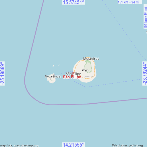
São Filipe GPS coordinates[2]
14° 53' 45.96" North, 24° 29' 44.016" West
| Map corner | latitude | longitude |
|---|---|---|
| Upper-left | 15.57451°, | -25.19869° |
| Center: | 14.8961°, | -24.49556° |
| Lower-right: | 14.21555°, | -23.79244° |
| Map W x H: | 151.1×151.1 km | = 93.9×93.9mi |
| max Lat: | 17.20171° ⇑91.7% North |
| São Filipe: | 14.8961° |
| min Lat: | ⇓8.3% South 14.87139° |
| min Long | São Filipe | max Long |
| -25.09217° | -24.49556° | -22.90509° |
| W 25%⇐ | ⇒75% E |
Elevation
Elevation of São Filipe is 103 m = 338 ft, and this is 14.8 m = 49 ft below average elevation for this country.
| Max E: |
480 m = 1575 ft | 29.2% |
| Avg. | 117.8 m = 386 ft | |
| São Filipe | 103 m = 338 ft | |
Min E: |
1 m = 3 ft | 70.8% |
See also: Cape Verde elevation on elevation.city.
Geographical zone
São Filipe is located in North Torrid zone (between Equator and Tropic of Cancer). Distance of this Northern Tropic circle is 949.6 km =590.1 mi to North.| Distance of | km | miles | from São Filipe |
|---|---|---|---|
| North Pole | 8350.8 | 5188.9 | to North |
| Arctic Circle | 5744.9 | 3569.7 | to North |
| Tropic Cancer | 949.6 | 590.1 | to North |
| Equator | 1656.3 | 1029.2 | to South |


Nearby cities:
15 places around São Filipe: (largest is in red/bold)
• Assomada
90.1 km =56 mi,  75°
75°
• Calheta
102.2 km =63.5 mi,  71°
71°
• Cidade Velha
95.7 km =59.5 mi,  88°
88°
• Cova Figueira
21.7 km =13.5 mi, 91°
• Igreja
23.9 km =14.9 mi,  50°
50°
• João Teves
99.2 km =61.6 mi, 78°
• Nova Sintra
21.7 km =13.5 mi,  262°
262°
• Pedra Badejo
107 km =66.5 mi, 75°
• Picos
95 km =59 mi, 77°
• Praia
105.7 km =65.7 mi, 87°
• Santa Cruz
103.2 km =64.1 mi, 75°
• São Domingos
101.2 km =62.9 mi, 81°
• Tarrafal
90.5 km =56.2 mi,  61°
61°
• Tarrafal de São Nicolau
186.3 km =115.8 mi,  4°
4°
• Vila do Maio
140.5 km =87.3 mi, 78°
Sources, notices
• [Note1] Compared only with cities in Cape Verde existing in our database
• [Src1] Map data: © OpenStreetMap contributors (CC-BY-SA)
• [Src2] Other city data from geonames.org with taken over terms of usage.
• [Src3] Geographical zone / Annual Mean Temperature by Robert A. Rohde @ Wikipedia
