Tarrafal geodata
Tarrafal is a seat of a first-order administrative division; located in Cape Verde in Atlantic/Cape_Verde (GMT-1) time zone. With population of 6,463 people, there are 8 cities with bigger population in this country. Compared to other cities in Cape Verde, 58.3% of cities are located further ↓South; 54.2% of cities are located further →East and 70.8% of cities have higher elevation than Tarrafal. Note1


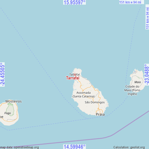
Tarrafal GPS coordinates[2]
15° 16' 43.716" North, 23° 45' 6.912" West
| Map corner | latitude | longitude |
|---|---|---|
| Upper-left | 15.95597°, | -24.45505° |
| Center: | 15.27881°, | -23.75192° |
| Lower-right: | 14.59946°, | -23.0488° |
| Map W x H: | 150.8×150.8 km | = 93.7×93.7mi |
| max Lat: | 17.20171° ⇑41.7% North |
| Tarrafal: | 15.27881° |
| min Lat: | ⇓58.3% South 14.87139° |
| min Long | Tarrafal | max Long |
| -25.09217° | -23.75192° | -22.90509° |
| W 45.8%⇐ | ⇒54.2% E |
Elevation
Elevation of Tarrafal is 17 m = 56 ft, and this is 100.8 m = 331 ft below average elevation for this country.
| Max E: |
480 m = 1575 ft | 70.8% |
| Avg. | 117.8 m = 386 ft | |
| Tarrafal | 17 m = 56 ft | |
Min E: |
1 m = 3 ft | 29.2% |
See also: Cape Verde elevation on elevation.city.
Geographical zone
Tarrafal is located in North Torrid zone (between Equator and Tropic of Cancer). Distance of this Northern Tropic circle is 907.1 km =563.6 mi to North.| Distance of | km | miles | from Tarrafal |
|---|---|---|---|
| North Pole | 8308.2 | 5162.5 | to North |
| Arctic Circle | 5702.3 | 3543.2 | to North |
| Tropic Cancer | 907.1 | 563.6 | to North |
| Equator | 1698.8 | 1055.6 | to South |


Nearby cities:
15 places around Tarrafal: (largest is in red/bold)
• Assomada
21.2 km =13.2 mi,  159°
159°
• Calheta
20 km =12.4 mi,  121°
121°
• Cidade Velha
43.4 km =27 mi, 158°
• Cova Figueira
72.4 km =45 mi,  233°
233°
• Igreja
67.3 km =41.8 mi,  246°
246°
• João Teves
29.3 km =18.2 mi,  143°
143°
• Nova Sintra
111 km =69 mi, 245°
• Pedra Badejo
28.5 km =17.7 mi, 123°
• Picos
25.2 km =15.7 mi,  149°
149°
• Praia
46.4 km =28.8 mi, 146°
• Sal Rei
133.9 km =83.2 mi,  41°
41°
• Santa Cruz
25.6 km =15.9 mi,  129°
129°
• São Domingos
34.8 km =21.6 mi, 144°
• São Filipe
90.5 km =56.2 mi,  241°
241°
• Vila do Maio
60 km =37.3 mi,  105°
105°
Sources, notices
• [Note1] Compared only with cities in Cape Verde existing in our database
• [Src1] Map data: © OpenStreetMap contributors (CC-BY-SA)
• [Src2] Other city data from geonames.org with taken over terms of usage.
• [Src3] Geographical zone / Annual Mean Temperature by Robert A. Rohde @ Wikipedia
