Lichtenau geodata
Lichtenau (North Rhine-Westphalia) is a populated place; located in Germany in Europe/Berlin (GMT+2) time zone. With population of 11,268 people, there are 1468 cities with bigger population in this country. Compared to other cities in Germany, 67.9% of cities are located further ↓South; 66.7% of cities are located further →East and 62.2% of cities have lower elevation than Lichtenau. Note1
Administrative division(s):
- Level 1: North Rhine-Westphalia
- Level 2: Regierungsbezirk Detmold
- Level 3: Kreis Paderborn
- Level 4: Lichtenau


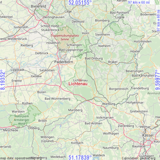
Lichtenau GPS coordinates[2]
51° 37' 1.452" North, 8° 53' 47.94" East
| Map corner | latitude | longitude |
|---|---|---|
| Upper-left | 52.05155°, | 8.19352° |
| Center: | 51.61707°, | 8.89665° |
| Lower-right: | 51.17839°, | 9.59977° |
| Map W x H: | 97.1×97.1 km | = 60.3×60.3mi |
| max Lat: | 55.01917° ⇑32.1% North |
| Lichtenau: | 51.61707° |
| min Lat: | ⇓67.9% South 47.40724° |
| min Long | Lichtenau | max Long |
| 5.92978° | 8.89665° | 14.98853° |
| W 33.3%⇐ | ⇒66.7% E |
Elevation
Elevation of Lichtenau is 303 m = 994 ft, and this is 53.9 m = 177 ft above average elevation for this country.
| Max E: |
1256 m = 4121 ft | 37.8% |
| Lichtenau | 303 m 994 ft | |
| Avg. | 249.1 m = 817 ft | |
Min E: |
-5 m = -16 ft | 62.2% |
See also: Germany elevation on elevation.city.
Geographical zone
Lichtenau is located in North temperate zone (between Tropic of Cancer and the Arctic Circle). Distance of this North polar circle is 1661.9 km =1032.7 mi to North.| Distance of | km | miles | from Lichtenau |
|---|---|---|---|
| North Pole | 4267.8 | 2651.9 | to North |
| Arctic Circle | 1661.9 | 1032.7 | to North |
| Tropic Cancer | 3133.4 | 1947 | to South |
| Equator | 5739.3 | 3566.2 | to South |


Nearby cities:
15 places around Lichtenau: (largest is in red/bold)
• Altenbeken
16.7 km =10.4 mi,  10°
10°
• Bad Driburg
15.4 km =9.6 mi,  33°
33°
• Bad Lippspringe
19.3 km =12 mi,  343°
343°
• Borgentreich
24.4 km =15.2 mi,  102°
102°
• Brakel
22.9 km =14.2 mi,  60°
60°
• Büren
24.4 km =15.2 mi,  252°
252°
• Marsberg
17.6 km =10.9 mi,  190°
190°
• Nieheim
25.7 km =16 mi,  35°
35°
• Paderborn
15 km =9.3 mi,  319°
319°
• Rhoden
17.8 km =11.1 mi,  153°
153°
• Salzkotten
21.3 km =13.2 mi,  286°
286°
• Schlangen
21.7 km =13.5 mi,  350°
350°
• Warburg
22.3 km =13.9 mi,  129°
129°
• Willebadessen
9.7 km =6 mi,  84°
84°
• Wünnenberg
17.4 km =10.8 mi,  231°
231°
Sources, notices
• [Note1] Compared only with cities in Germany existing in our database
• [Src1] Map data: © OpenStreetMap contributors (CC-BY-SA)
• [Src2] Other city data from geonames.org with taken over terms of usage.
• [Src3] Geographical zone / Annual Mean Temperature by Robert A. Rohde @ Wikipedia
