Willebadessen geodata
Willebadessen (North Rhine-Westphalia) is a populated place; located in Germany in Europe/Berlin (GMT+2) time zone. With population of 8,821 people, there are 1818 cities with bigger population in this country. Compared to other cities in Germany, 68% of cities are located further ↓South; 64.9% of cities are located further →East and 50.5% of cities have higher elevation than Willebadessen. Note1
Administrative division(s):
- Level 1: North Rhine-Westphalia
- Level 2: Regierungsbezirk Detmold
- Level 3: Kreis Höxter
- Level 4: Willebadessen


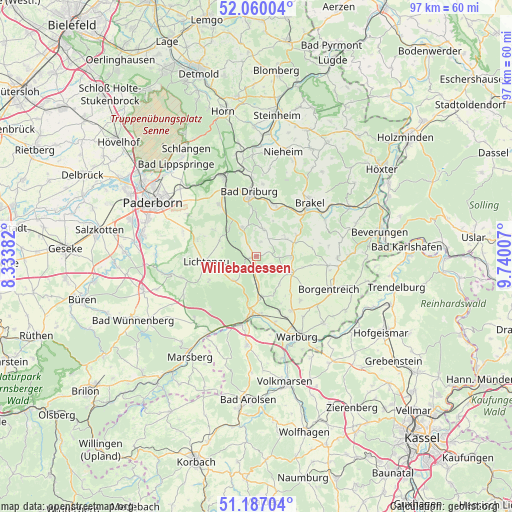
Willebadessen GPS coordinates[2]
51° 37' 32.304" North, 9° 2' 12.984" East
| Map corner | latitude | longitude |
|---|---|---|
| Upper-left | 52.06004°, | 8.33382° |
| Center: | 51.62564°, | 9.03694° |
| Lower-right: | 51.18704°, | 9.74007° |
| Map W x H: | 97.1×97.1 km | = 60.3×60.3mi |
| max Lat: | 55.01917° ⇑32% North |
| Willebadessen: | 51.62564° |
| min Lat: | ⇓68% South 47.40724° |
| min Long | Willebadessen | max Long |
| 5.92978° | 9.03694° | 14.98853° |
| W 35.1%⇐ | ⇒64.9% E |
Elevation
Elevation of Willebadessen is 221 m = 725 ft, and this is 28.1 m = 92 ft below average elevation for this country.
| Max E: |
1256 m = 4121 ft | 50.5% |
| Avg. | 249.1 m = 817 ft | |
| Willebadessen | 221 m = 725 ft | |
Min E: |
-5 m = -16 ft | 49.5% |
See also: Germany elevation on elevation.city.
Geographical zone
Willebadessen is located in North temperate zone (between Tropic of Cancer and the Arctic Circle). Distance of this North polar circle is 1660.9 km =1032 mi to North.| Distance of | km | miles | from Willebadessen |
|---|---|---|---|
| North Pole | 4266.8 | 2651.3 | to North |
| Arctic Circle | 1660.9 | 1032 | to North |
| Tropic Cancer | 3134.3 | 1947.6 | to South |
| Equator | 5740.2 | 3566.8 | to South |


Nearby cities:
15 places around Willebadessen: (largest is in red/bold)
• Altenbeken
16.8 km =10.4 mi,  337°
337°
• Bad Driburg
12 km =7.5 mi,  354°
354°
• Bad Lippspringe
23.2 km =14.4 mi,  319°
319°
• Beverungen
23.7 km =14.7 mi,  78°
78°
• Borgentreich
15.4 km =9.6 mi,  113°
113°
• Brakel
14.5 km =9 mi,  45°
45°
• Lichtenau
9.7 km =6 mi,  264°
264°
• Liebenau
22.2 km =13.8 mi,  130°
130°
• Marsberg
22.4 km =13.9 mi,  215°
215°
• Nieheim
20.6 km =12.8 mi,  14°
14°
• Paderborn
22.1 km =13.7 mi,  298°
298°
• Rhoden
17 km =10.6 mi,  186°
186°
• Schlangen
24.3 km =15.1 mi,  327°
327°
• Volkmarsen
24.7 km =15.3 mi,  166°
166°
• Warburg
16.9 km =10.5 mi,  153°
153°
Sources, notices
• [Note1] Compared only with cities in Germany existing in our database
• [Src1] Map data: © OpenStreetMap contributors (CC-BY-SA)
• [Src2] Other city data from geonames.org with taken over terms of usage.
• [Src3] Geographical zone / Annual Mean Temperature by Robert A. Rohde @ Wikipedia
