Burglengenfeld geodata
Burglengenfeld (Bavaria) is a populated place; located in Germany in Europe/Berlin (GMT+2) time zone. With population of 12,095 people, there are 1358 cities with bigger population in this country. Compared to other cities in Germany, 80.2% of cities are located further ↑North; 82.4% of cities are located further ←West and 71.3% of cities have lower elevation than Burglengenfeld. Note1
Administrative division(s):
- Level 1: Bavaria
- Level 2: Upper Palatinate
- Level 3: Landkreis Schwandorf
- Level 4: Burglengenfeld


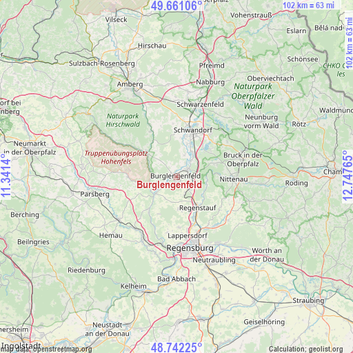
Burglengenfeld GPS coordinates[2]
49° 12' 13.644" North, 12° 2' 40.272" East
| Map corner | latitude | longitude |
|---|---|---|
| Upper-left | 49.66106°, | 11.3414° |
| Center: | 49.20379°, | 12.04452° |
| Lower-right: | 48.74225°, | 12.74765° |
| Map W x H: | 102.2×102.2 km | = 63.5×63.5mi |
| max Lat: | 55.01917° ⇑80.2% North |
| Burglengenfeld: | 49.20379° |
| min Lat: | ⇓19.8% South 47.40724° |
| min Long | Burglengenfeld | max Long |
| 5.92978° | 12.04452° | 14.98853° |
| W 82.4%⇐ | ⇒17.6% E |
Elevation
Elevation of Burglengenfeld is 368 m = 1207 ft, and this is 118.9 m = 390 ft above average elevation for this country.
| Max E: |
1256 m = 4121 ft | 28.7% |
| Burglengenfeld | 368 m 1207 ft | |
| Avg. | 249.1 m = 817 ft | |
Min E: |
-5 m = -16 ft | 71.3% |
See also: Germany elevation on elevation.city.
Geographical zone
Burglengenfeld is located in North temperate zone (between Tropic of Cancer and the Arctic Circle). Distance of this North polar circle is 1930.2 km =1199.4 mi to North.| Distance of | km | miles | from Burglengenfeld |
|---|---|---|---|
| North Pole | 4536.1 | 2818.6 | to North |
| Arctic Circle | 1930.2 | 1199.4 | to North |
| Tropic Cancer | 2865 | 1780.2 | to South |
| Equator | 5470.9 | 3399.5 | to South |


Nearby cities:
15 places around Burglengenfeld: (largest is in red/bold)
• Brunn
11.3 km =7 mi,  71°
71°
• Brunn
15.6 km =9.7 mi,  222°
222°
• Duggendorf
13.4 km =8.3 mi, 223°
• Hohenfels
14.2 km =8.8 mi,  270°
270°
• Holzheim bei Oder
11.3 km =7 mi,  51°
51°
• Kallmünz
7.7 km =4.8 mi,  232°
232°
• Maxhütte-Haidhof
3.5 km =2.2 mi,  97°
97°
• Regenstauf
11.2 km =7 mi,  146°
146°
• Rieden
15.3 km =9.5 mi,  330°
330°
• Schmidmühlen
11.3 km =7 mi,  309°
309°
• Schwandorf in Bayern
14.3 km =8.9 mi,  19°
19°
• Steinberg
13.4 km =8.3 mi, 48°
• Teublitz
3.8 km =2.4 mi,  55°
55°
• Wolfsegg
11.8 km =7.3 mi,  204°
204°
• Zeitlarn
14.8 km =9.2 mi,  160°
160°
Sources, notices
• [Note1] Compared only with cities in Germany existing in our database
• [Src1] Map data: © OpenStreetMap contributors (CC-BY-SA)
• [Src2] Other city data from geonames.org with taken over terms of usage.
• [Src3] Geographical zone / Annual Mean Temperature by Robert A. Rohde @ Wikipedia
